长江科学院院报 ›› 2024, Vol. 41 ›› Issue (8): 180-188.DOI: 10.11988/ckyyb.20230594

• 数字孪生基础理论与关键技术研究专栏 • 上一篇    下一篇

数字孪生驱动的长江流域干旱防御平台设计与开发

李喆1,2(), 向大享1,2, 陈喆1,2, 崔长露1,2   

  1. 1 长江科学院 空间信息技术应用研究所,武汉 430010
    2 长江科学院 武汉市智慧流域工程技术研究中心,武汉 430010
  • 收稿日期:2023-05-30 修回日期:2023-07-05 出版日期:2024-08-28 发布日期:2024-08-13
  • 作者简介:

    李 喆(1980-),男,湖北监利人,正高级工程师,博士后,研究方向为防汛抗旱减灾、水利信息化、水土保持。E-mail:

  • 基金资助:
    国家重点研发计划项目(2021YFC3000205); 国家重点研发计划项目(2017YFC1502406); 武汉市重点研发计划项目(CKSD2023927/KJ); 水利部重大科技项目(SKR-2022001); 水利部重大科技项目(SKR-2022003); 湖北省自然科学基金项目(2022CFD173); 中央部门预算项目(2136703)

Drought Resistance Information Platform Driven by Digital Twins for the Changjiang River Basin: Design and Development

LI Zhe1,2(), XIANG Da-xiang1,2, CHEN Zhe1,2, CUI Chang-lu1,2   

  1. 1 Spatial Information Technology Application Department,Changjiang River Scientific Research Institute,Wuhan 430010, China
    2 Wuhan Smart Watershed Engineering Technology Research Center, Changjiang River Scientific Research Institute,Wuhan 430010,China
  • Received:2023-05-30 Revised:2023-07-05 Published:2024-08-28 Online:2024-08-13

摘要:

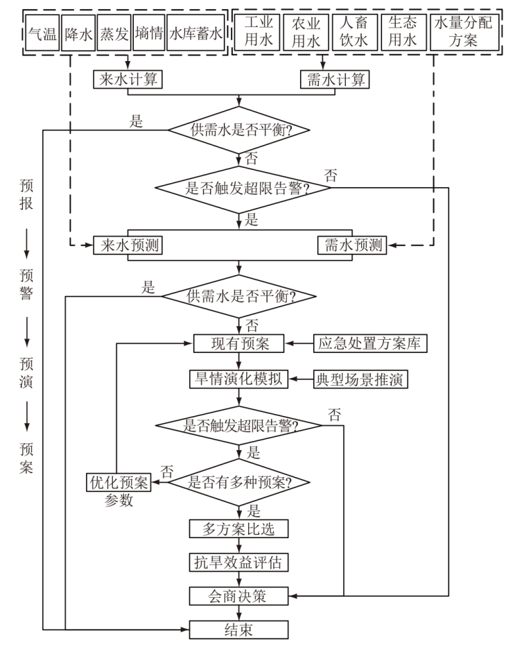
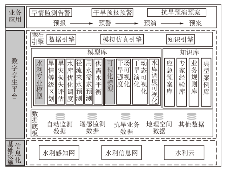
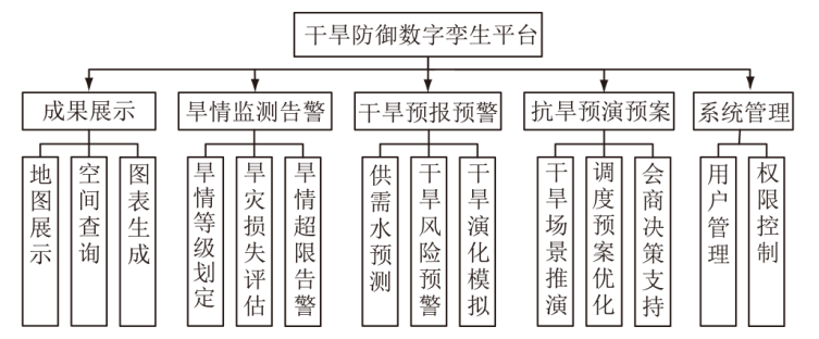
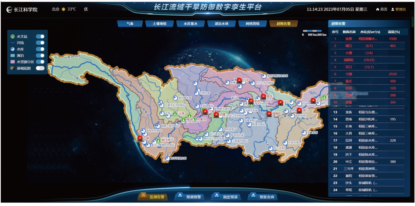
在全球气候变化的背景下,长江流域发生了多次严重的高温干旱灾害,流域抗旱管理面临着旱情监测告警效率较低、旱灾预报预警精度不高、抗旱预案推演能力不足等瓶颈,迫切需要开展数字化转型。从长江流域抗旱减灾业务管理和“四预”应用需求出发,基于智慧水利和数字孪生建设的总体要求,综合运用WebGL、GIS等技术,建立了干旱防御数字孪生平台,研发了遥感干旱监测评估、干旱专业模型动态加载、旱警水位超限预警、抗旱预案可视化等关键技术,初步实现了“预报-预警-预演-预案”全链条贯通业务应用,切实提升了长江流域抗旱管理智能化、精细化水平,为流域干旱防灾减灾提供了技术支撑。

关键词: 长江流域, 干旱防御信息平台, 数字孪生, 四预

Abstract:

In the context of global climate change, the Changjiang River basin has suffered from multiple severe high temperatures and drought disasters. Drought resistance management in the basin is faced with such bottleneck problems as low efficiency of drought monitoring and warning, inadequate accuracy of drought prediction and early-warning, and insufficient ability to deduce drought plans. To address these issues, digital transformation has become exigent. In line with the comprehensive requirements of smart water conservancy and digital twin technology, a digital twin platform for drought prevention has been constructed by utilizing WebGL and GIS to meet the operational management requirements of drought resistance and disaster mitigation in the Changjiang River Basin, aligning with the demands of the “forecast, early warning, preview, and contingency planning” principles. Key technologies have been developed, including remote sensing drought monitoring and evaluation, dynamic loading of drought-specific models, early-warning of water levels exceeding drought limit, and visualization of drought reduction plans. Consequently, the business application covering the full chain of “forecast, early warning, preview, and contingency planning” has been achieved. This has effectively improved the intelligent and refined level of drought resistance management in the Changjiang River Basin, providing technical support for drought prevention and disaster reduction in the basin.

Key words: Changjiang River Basin, drought defense information platform, digital twin, forecast, early-warning, preview, and contingency planning

中图分类号: