长江科学院院报 ›› 2024, Vol. 41 ›› Issue (8): 164-171.DOI: 10.11988/ckyyb.20230268

• 水利信息化 • 上一篇    下一篇

基于多源多时相影像的鄱阳湖水体提取及时空变化分析

乐颖1,2(), 刘聚涛1,2(), 文慧1,2   

  1. 1 江西省水利科学院,南昌 330029
    2 江西省鄱阳湖流域生态水利技术创新中心,南昌 330029
  • 收稿日期:2023-03-14 修回日期:2023-07-10 出版日期:2024-08-01 发布日期:2024-08-13
  • 通讯作者: 刘聚涛(1983-),男,河南舞阳人,正高级工程师,博士,研究方向为生态监测与评价。E-mail:
  • 作者简介:

    乐 颖(1998-),女,江西抚州人,硕士研究生,研究方向为水利生态环境与遥感。E-mail:

  • 基金资助:
    国家自然科学基金项目(42161016); 江西省科技厅重点研发项目(20212BBG71002); 江西省科技厅揭榜挂帅项目(20213AAG01012); 江西省水利厅科技项目(202324YBKT07)

Extraction and Spatiotemporal Variation of Poyang Lake Water Body Based on Multi-source and Multi-phase Images

LE Ying1,2(), LIU Ju-tao1,2(), WEN Hui1,2   

  1. 1 Jiangxi Academy of Water Science and Engineering,Nanchang 330029,China
    2 Jiangxi Provincial Technology Innovation Center for Ecological Water Engineering in Poyang Lake Basin, Nanchang 330029,China
  • Received:2023-03-14 Revised:2023-07-10 Published:2024-08-01 Online:2024-08-13

摘要:

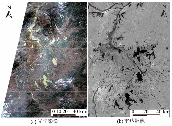
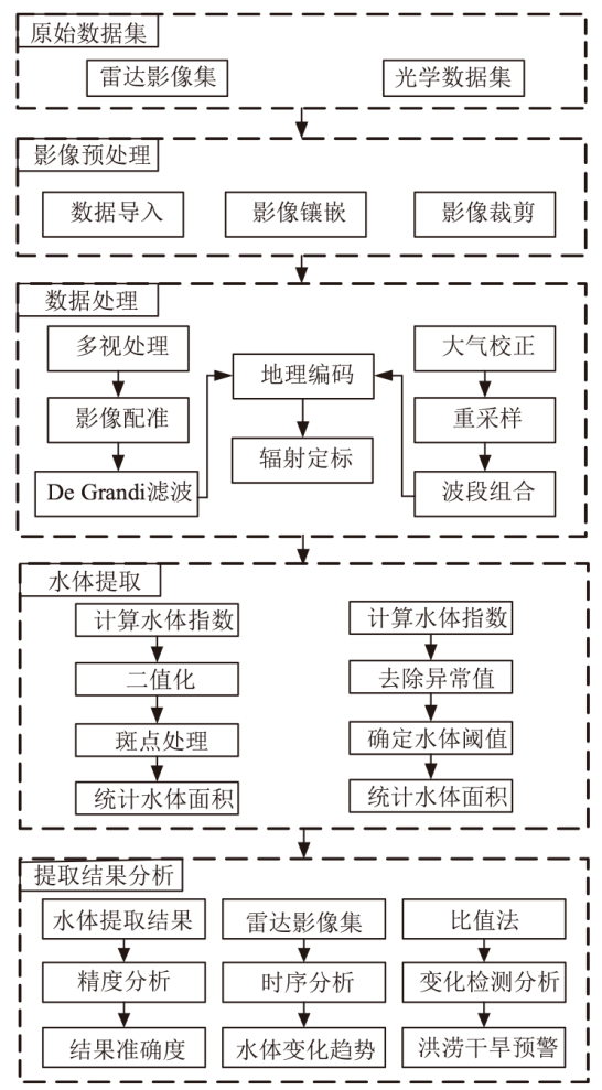
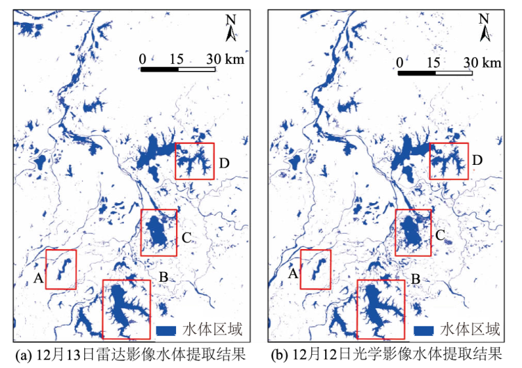
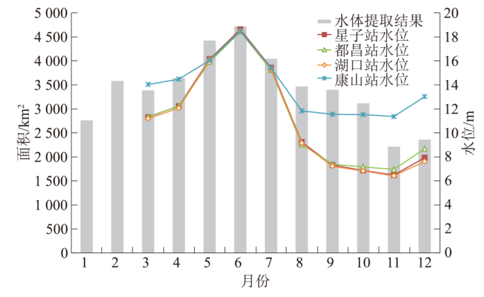
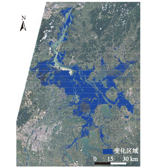
鄱阳湖水体面积受气候变化的影响呈现季节性变化,为了更好地探究其变化规律,提出了一种结合多时相雷达影像和光学数据的水体信息提取方法。以Sentinel-1A雷达影像和Sentinel-2光学影像为研究数据,首先对遥感影像集进行一系列数据预处理,利用Sentinel-1双极化水体指数(SDWI)和改进的归一化差异水体指数(MNDWI)分别提取出雷达影像和光学数据中湖区边界,并根据湖区范围计算出水体面积,从精度、时序和变化检测3个方面评价水体提取结果的准确性,对比分析湖区面积变化趋势,为鄱阳湖管理与保护提供科学的灾害预警。结果表明:①利用雷达影像和光学遥感数据提取鄱阳湖的水体结果基本一致,在提取农田、细小水体及有云区域时,雷达影像提取效果优于光学影像提取效果,说明借助雷达影像提取完整水体信息更具优势。②鄱阳湖平水期、丰水期和枯水期水体面积的均值分别为3 686.49、4 077.73、2 612.81 km2,其中丰水期水量是枯水期水量的1.56倍。③雷达影像时序水体提取结果与星子站、都昌站、湖口站和康山站共4个水文站水位数据变化趋势具有较高的一致性,Pearson相关系数分别为0.89、0.87、0.90、0.81。

关键词: 鄱阳湖, 水体提取, 时空变化, MNDWI, SDWI, 变化检测

Abstract:

Under the influence of climate change, the water area of Poyang Lake exhibits seasonal fluctuations. To elucidate these changes comprehensively, we propose a water information extraction approach that integrates multi-temporal radar images and optical data. Leveraging Sentinel-1A radar images and Sentinel-2 optical images as our research datasets, we initiated a sequence of data preprocessing steps on the remote sensing image set. Employing the Sentinel-1 dual polarized water index (SDWI) and the improved normalized differential water index (MNDWI), we delineated the lake’s boundary and computed its water area using radar and optical data. The precision, timing, and change detection of our water extraction results were evaluated meticulously. Analyzing the lake area’s change trends aims to furnish scientific insights for disaster management and Poyang Lake’s conservation. Our findings revealed that: 1)The water bodies of Poyang Lake extracted from radar and optical remote sensing data were mostly congruent. Radar image extraction outperformed optical image extraction when delineating farmlands, small water bodies, and cloud-covered areas, suggesting radar images’ superiority in capturing comprehensive water information. 2)The average water area of Poyang Lake during normal, wet, and dry seasons is 3 686.49, 4 077.73, and 2 612.81 km2, respectively, with the wet season’s water volume being 1.56 times that of the dry season. 3)Time-series water extraction results from radar images exhibited strong consistency with water level variation data from Xingzi Station, Duchang Station, Hukou Station, and Kangshan Station, yielding Pearson correlation coefficients of 0.89, 0.87, 0.90, and 0.81, respectively.

Key words: Poyang Lake, water extraction, spatiotemporal variation, MNDWI, SDWI, change detection

中图分类号: