River-lake Protection and Regulation

Dynamic-Geomorphic Coupling Mechanism Influencing Sediment Deposition Intensity in Tidal Estuarine Bar Fields:A Case Study of Spur Dike Fields in the North Passage of Yangtze River Estuary

  • ZHANG Gong-jin ,
  • QIAN Ming-xia ,
  • ZHU Xian-bo
Expand
  • River and Harbor Engineering Department, Nanjing Hydraulic Research Institute, Nanjing 210029, China

Received date: 2025-02-21

  Revised date: 2025-05-13

  Online published: 2025-07-11

Abstract

[Objective] This study centers on the dike fields of the spur dike group in the Yangtze River Estuary, a typical tidal estuary where complex water-sediment dynamics and diverse dike layouts jointly shape deposition processes. Its core objectives are twofold: first, to unravel the coupling mechanism through which dynamic factors (e.g., runoff, tides) and geomorphic parameters (e.g., dike spacing, initial water depth) jointly regulate sediment deposition intensity in tidal estuarine dike fields; second, to develop a reliable empirical formula for predicting such deposition intensity. By addressing the gap in existing research—where the integrated effects of dynamic and geomorphic factors are often overlooked—this study aims to provide robust theoretical support for optimizing the design of spur dike groups and enhancing the accuracy of deposition forecasting in the Yangtze River Estuary and analogous tidal estuarine systems worldwide. [Methods] The dike fields of the spur dike group in the north passage of the Yangtze River Estuary, a key area of the Yangtze River Estuary Deepwater Channel Regulation Project, were selected as the research focus. Long-term, systematic measured data were analyzed, including dike field topographic surveys, hydrological observations, and sediment monitoring records. Correlation analysis was first performed to examine how deposition intensity relates to key dynamic factors (upstream runoff from the Datong Hydrological Station, suspended sediment concentration, offshore tidal range, suspended sediment particle size) and critical geomorphic parameters (relative spacing of spur dikes, initial water depth of dike fields, spur dike length, dike field depth). Using dimensional analysis and the Buckingham π theorem, a comprehensive dynamic parameter was constructed by integrating the four dynamic factors, synthesizing their combined influence on water-sediment transport and deposition. Simultaneously, a set of geomorphic parameters was established, incorporating spur dike spacing, length, and dike field depth to quantify the impact of spur dike group layout and dike field topographic features on local flow patterns and sediment trapping. A power function model was then used to quantify the coupling relationship between the comprehensive dynamic parameter and geomorphic parameters, and an empirical formula for deposition intensity was derived. Finally, the formula was validated using measured data from representative dike fields, including those unaffected by subsequent engineering and those influenced by phased projects. [Results] 1) As the Yangtze River Estuary Deepwater Channel Regulation Project advanced through three phases, total sediment deposition in dike fields increased significantly (from 15.48×10⁶ m3 in Phase I to 128.01×10⁶ m3 in Phase II), confirming the spur dike group’s strong sediment-trapping effect. 2) Deposition intensity was positively correlated with runoff (higher runoff carries more sediment to dike fields) and sediment concentration (more available sediment for deposition), but negatively correlated with tidal range (larger tidal range strengthens ebb currents, enhancing offshore sediment transport) and sediment particle size (coarser particles settle before reaching dike fields or are easily resuspended by strong flows). 3) Among geomorphic parameters, initial dike field water depth showed a strong positive linear correlation with deposition intensity (deeper water provides more deposition space and reduces flow velocity, favoring sediment settlement), while spur dike relative spacing had weak correlation (R2=0.44), due to interactions with factors like flow blockage (too small spacing) or uneven energy distribution (too large spacing). 4) The comprehensive dynamic parameter correlated highly (R2=0.94) with annual deposition in undisturbed dike fields (TS1, TS2), effectively capturing dynamic drivers of deposition; geomorphic parameters correlated strongly (R2=0.96) with initial deposition, clearly distinguishing differences between dike fields in the same spur dike group. 5) The empirical formula showed excellent agreement with measured data: it matched well with the measured deposition intensity of TS1, TS2, and TS8 (used for fitting analysis) and effectively reflected the deposition intensity of TN7, TN8, and TN9 (used for validation in the second-phase project). Even for dike fields affected by phased engineering or new structures (e.g., a 21 km sediment barrier), the formula still successfully captured the overall deposition trend. [Conclusion] This study makes three key contributions: it innovatively integrates dynamic factors and geomorphic parameters into a unified analytical framework for Yangtze River Estuary spur dike group dike fields, overcoming the limitations of previous single-factor research; the constructed comprehensive dynamic parameter and geomorphic parameters effectively quantify the combined effects of water-sediment dynamics and dike layout/topography on deposition, making complex processes interpretable; the empirical formula, with high applicability and accuracy, offers a reliable tool for tidal estuarine dike field deposition prediction.

Cite this article

ZHANG Gong-jin , QIAN Ming-xia , ZHU Xian-bo . Dynamic-Geomorphic Coupling Mechanism Influencing Sediment Deposition Intensity in Tidal Estuarine Bar Fields:A Case Study of Spur Dike Fields in the North Passage of Yangtze River Estuary[J]. Journal of Changjiang River Scientific Research Institute, 2025 , 42(12) : 1 -7 . DOI: 10.11988/ckyyb.20250130

0 引言

丁坝作为河流整治工程中广泛应用的整治建筑物,通常用于海岸工程防护、通航水深维护以及河道生态修复等工程。潮汐河口地区的水沙动力条件(如径流、潮汐、波浪、泥沙输运等)是影响坝田淤积强度的关键因素。这些动力因子首先通过复杂的相互作用,引发了泥沙的输运、沉积和再悬浮过程,进而影响坝田的淤积模式。其次,丁坝与主槽之间通过界面混合层发生动量和质量的交换,其中动量与质量的交换主要通过混合层界面的紊动输运实现[1]。坝田口门的宽度与长度比等丁坝平面布置也是影响坝田水流特性的关键因素[2]
径流是河口地区泥沙的主要来源之一,其流量和含沙量直接影响坝田的淤积强度。高径流输沙量会显著增加坝田区域的泥沙沉积,尤其是在洪水季节,大量泥沙被携带至河口并沉积在坝田区域[3]。径流泥沙的粒径分布也会影响淤积过程,较粗的泥沙颗粒更容易在坝田区域沉积,而细颗粒泥沙则可能被潮汐和波浪再悬浮并输运至更远的海域[4]。潮差和潮流强度直接影响泥沙的输运和沉积过程。大潮差通常伴随着较强的潮汐流,能够将更多的泥沙输运至坝田区域,导致淤积强度增加[5]。潮汐不对称性(如涨潮与落潮的流速差异)也会影响泥沙的净输运方向,进而影响坝田的淤积模式[6]。丁坝的平面布局对坝田淤积强度及其空间分布产生显著影响。宽坝田与窄坝田在与主流的交换机制上表现出显著差异。Uijttewaal[7]通过坝田浓度试验揭示,窄坝田与主流的交换主要通过混合层迅速完成,而回流区核心与主流的交换则受上游坝头分离的大涡体控制,交换速度较快;然而,由于大涡体难以到达副环流区域,坝田浓度的衰减在后期阶段显著减缓。Weitbrecht等[8]的研究进一步指出,随着丁坝地貌参数的增加,坝田与主槽之间的交换速度也随之增大。Yossef等[9]通过分析坝田底沙输沙率与主流底沙输沙率的关系指出,在出水丁坝条件下,底沙向坝田的补给主要发生在坝田口门的下段;而在淹没状态下,底沙补给则分布于整个口门区域,其中下段的补给量相对较多。Sanchez-Cabeza等[10]对坝田交界面涡量分布的研究表明,界面附近的涡量较易穿过界面,表层的质量交换方向由坝田指向航道。Sukhodolov等[11]基于Elbe河Magdeburg河段的实测数据分析发现,水体含沙量从口门向坝田内部逐渐减少,流场分析进一步表明,坝田口门的上段和下段分别出现泥沙的净流出和净流入现象。孙士勇[12]通过研究揭示了坝田淤积厚度与淤积时间和泥沙粒径之间的关系。孔祥柏等[13]通过弯道整治试验研究,探讨了丁坝群整治工程的平面布置原则。韩玉芳等[14]从工程实际需求出发,对天然条件下的丁坝群工程布置形式进行了对比试验研究。淤积强度是衡量丁坝拦截泥沙效果的重要指标,研究表明,丁坝的长度、高度、间距和角度等地貌参数与淤积强度之间存在复杂的非线性关系[15]。例如,丁坝间距的减小虽能增加坝田区域的淤积强度,但过小的间距可能导致水流阻塞,增加冲刷风险[16]。此外,丁坝的角度对水流方向及泥沙输运路径具有显著影响,进而影响淤积分布[17]
在潮汐河口区域,坝田淤积现象是水沙动力学特征与丁坝的平面布局相互作用的产物。然而,近年来,关于水沙动力学特征与丁坝布局耦合机制的研究仍然不足。阐明潮汐河口水沙动力学特征与丁坝布局对坝田淤积的耦合作用机制,不仅能够加深对河口动力地貌过程理论的理解,而且为丁坝工程的设计、优化与管理提供了科学的理论支撑。

1 长江口北槽坝田淤积过程分析

长江口是典型的潮汐河口,其水沙动力条件受上游径流、输沙和口外潮汐的共同作用。上游径流呈现显著的季节性变化,洪水期径流量大,输沙量高,而枯水期径流量和输沙量显著减少;年平均输沙量约为4.8亿t,泥沙以细颗粒悬沙为主,粒径分布呈现明显的空间分异。口外潮汐为不规则半日潮,平均潮差约2.6 m,涨落潮历时不对称,涨潮历时短而流速大,落潮历时长而流速小,导致泥沙净输运方向向海。
以长江口北槽丁坝群坝田淤积为例,结合实测地形资料,对丁坝建设后坝田内淤积特征进行分析。长江口深水航道治理工程分3期实施,共建设丁坝19座,形成17座坝田,其中北侧坝田9座(TN1—TN9),南侧坝田8座(TS1—TS8),如图1所示。
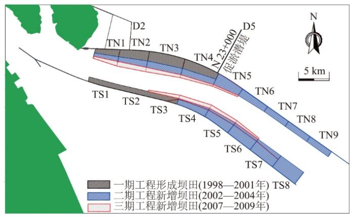
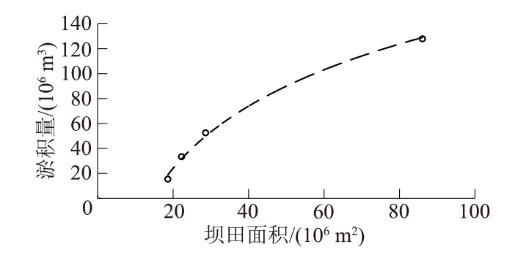
图1 长江口北槽丁坝群及坝田示意图

Fig.1 Sketch map of spur dikes and dike fields in the north passage of the Yangtze River estuary

丁坝群工程实施后坝田淤积与工程建设规模有关。根据不同区段丁坝建设后坝田淤积量统计发现,各区段坝田淤积均与坝田总面积有关。随着丁坝的新建和加长工程,对应坝田面积逐渐增加,相对时间内的坝田淤积量也就越大(如表1图2所示),坝田的促淤效果显著。
表1 长江口北槽丁坝群工程及淤积量统计

Table 1 Statistics of spur dike group project and siltation in the north passage of the Yangtze River Estuary

工程阶段 新增丁坝
长度/km
新增坝田面积/
(106 m2)
淤积量/(106 m3)
(工程建成后2 a)
一期 5.97 18.60 15.48
一期完善 5.23 28.61 52.58
二期 18.90 86.08 128.01
三期 4.63 22.24 33.44
图2 新增坝田面积与新增淤积量关系(以坝田建成后2 a淤积量进行分析)

Fig.2 Relationship between newly added dike field area and newly accumulated sediment volume

长江口北槽丁坝群均为垂直于导堤建设的出水丁坝,丁坝高度和角度基本一致,但丁坝间距和初始地形不同,因此通过分析各坝田相对间距W/L(W为两丁坝间距,L为两丁坝平均长度)和初始水深H0(丁坝建设前坝田范围内的平均水深)与坝田建成后的淤积强度之间的关系,发现坝田淤积强度受相对间距和初始水深影响显著(图3)。通过历年大通年均流量、年均含沙量和北槽中年均潮差对南侧坝田TS1和TS2在1999年建成后直至2010年期间坝田淤积强度的影响分析,发现坝田淤积强度对流量、含沙量和潮差的响应趋势也较为显著(图4)。因此进一步说明长江口北槽丁坝群坝田淤积强度受丁坝平面布置和长江口水沙动力条件的综合影响。
图3 长江口北槽各坝田地貌参数

Fig.3 Geomorphological parameters of each dike field in the North Passage of the Yangtze River Estuary

图4 历年坝田淤积强度及水沙动力变化

Fig.4 Siltation intensity and water and sediment dynamic changes of the dike field over years

2 坝田淤积强度的影响因素分析

潮汐河口丁坝群坝田淤积受多种因素综合影响,主要包括水流动力因素(如潮汐特征、径流特征和波浪作用)、泥沙特性因素(如泥沙粒径、级配和来源),这些因素相互作用决定了坝田区域的泥沙输运和淤积过程。根据长江口北槽丁坝群坝田建成后泥沙淤积实测资料对其进行影响因子分析。

2.1 动力过程因子

坝田淤积的影响因素较为复杂,一般认为坝田的淤积主要为回流淤积、异重流淤积和缓流淤积3种方式。岳建平[18]对盲肠河段内的淤积研究发现,其回流淤积是主导因素,主要受主流流速和含沙量的正相关影响,并构建了回流淤积强度公式,之后谢鉴衡[19]、刘清泉[20]对该公式分别进行了改进。黄才安等[21]认为潮汐河口段的坝田受坝田外的潮位、悬沙浓度、悬沙粒径等动力因素的影响。国内外研究普遍认为,潮汐河口坝田淤积除了受主流流速和含沙量的影响外,河口潮汐特征和悬沙粒径特征也是其主要影响动力因素,但对该动力因素的系统性分析较少。
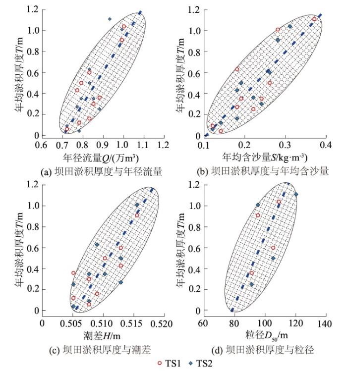
考虑TS1和TS2坝田在行程后无扩建等人类活动,因此,分别采用1999—2009年大通径流量、含沙量、北槽中潮差和北槽中悬沙粒径和对应的TS1和TS2坝田年均淤积厚度进行相关性分析(图5)。
图5 坝田淤积厚度与水沙动力变化相关性分析

Fig.5 Correlation analysis between siltation thickness and water and sediment dynamic change in dike field

研究发现:
(1)随着径流的增加,坝田内的泥沙淤积厚度也明显增加。这是因为径流的改变直接影响着主槽水动力的变化,当上游径流增大时,它携带的泥沙量也随之增加,这些泥沙在进入潮汐河口后,受到潮汐作用的影响,会在坝田区域沉积,从而增强淤积强度。
(2)随着含沙量的增加,坝田内的泥沙淤积厚度也明显增加。这是因为当水体中的含沙量较高时,随着潮汐的进退,更多的泥沙被输送至坝田区域,并在流速减缓时沉积下来,从而加剧了淤积的程度。
(3)随着潮差的增加,坝田内的泥沙淤积厚度显著减小。这是因为当潮差较小时,涨潮流占优导致泥沙向陆输运,进而导致更多的泥沙在坝田内淤积;而当潮差增大时,落潮动力的显著增强会形成净向海输沙,导致坝田冲刷。
(4)随着粒径的逐渐增加,坝田内的泥沙淤积厚度显著减小。这是由于粗颗粒泥沙沉速大,容易在进入坝田前快速落淤,并且不易被二次悬浮。
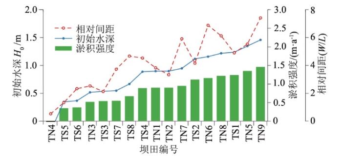
2.2 丁坝地貌因子

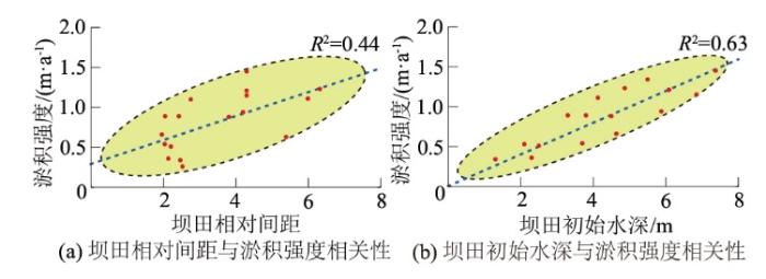
基于各坝田建成后坝田淤积实测资料,分析坝田淤积强度与坝田相对间距之间的相关性。通过相关性分析发现,丁坝相对间距对坝田淤积有一定的影响,但相关性较差(图6(a)),这是由于坝田淤积强度不仅受丁坝相对间距的影响,还受到水流条件、泥沙特性以及坝田初始水深的影响;此外,丁坝相对间距与淤积强度之间呈现非简单的线性关系:当丁坝间距较小时,水流可能被过度阻塞,导致局部冲刷增强,反而减少淤积强度;当丁坝间距较大时,虽然有利于泥沙沉积,但水流的能量分布可能不均匀,导致淤积强度的增加并不显著。通过相关性分析发现,丁坝之间初始水深越大,坝田淤积强度越大,基本呈线性相关(图6(b))。初始水深越大,水流速度减缓、泥沙输送能力下降、回流区扩大、沉积空间增加以及沉积物来源增多等因素共同作用,导致坝田淤积强度增大。
图6 坝田相对间距、初始水深与淤积强度相关性分析

Fig.6 Correlation analysis between initial water depth, relative spacing and siltation intensity of dike field

3 动力-地貌因素耦合分析

根据以上相关性分析,坝田淤积量的动力影响因素主要为上游径流量、含沙量、泥沙粒径和河口潮差,地貌因子主要为丁坝长度、高度、角度、间距和初始地形。通过拟合分析可知,以上动力因素与坝田淤积量均具有显著相关性。因此,可以认为坝田淤积量与这些因子之间存在一定的函数关系,即
$\mathrm{\Delta }\delta =f(Q,S,H,D,W,L,h,\theta ) 。$
式中:Δδ为单位时间淤积量,量纲为M/T;Q为径流量,量纲为L3/T;H为潮差,量纲为L;D为泥沙粒径,量纲为L;S为径流量,量纲为M/L3;W为丁坝间距,量纲为L;L为丁坝长度,量纲为L;h为坝田平均水深,量纲为L;θ为丁坝与岸线夹角,量纲为一。

3.1 综合动力参数构建

实际情况中,在坝田行程后,坝田淤积量主要受不同动力因素的影响,但单一动力因素无法准确反映坝田的淤积动力,且各动力因素之间也相互影响。因此,为更准确地分析影响坝田淤积趋势的动力因素,在潮汐河口坝田淤积量强度公式拟合过程中,结合QCHD,通过量纲分析和Buckingham π定理构分析,可得
$\mathrm{\Pi }=\mathrm{\Delta }{\delta }^{a}{Q}^{b}{S}^{c}{H}^{d}{D}^{e} 。$
式中:a、b、c、d、e均表示系数,引入综合动力参数PD(量纲为M/T),其表达式为
${P}_{D}={Q}^{b}{S}^{c}{H}^{d}{D}^{e} 。$
根据量纲和谐原理,有b=c=1,d=e=-1,则式(3)可表示为
${P}_{D}=\frac{QS}{HD} 。$
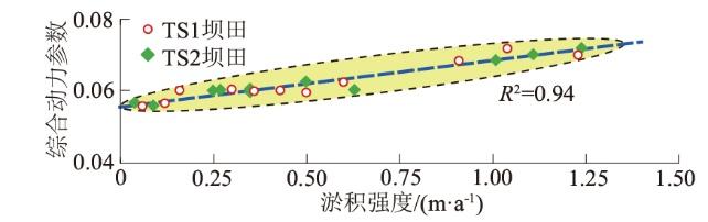
以长江口北槽丁坝群T1和T2坝田历年泥沙淤积强度与历年大通径流量、含沙量、北槽中泥沙中值粒径和北槽中的潮差计算综合动力参数PD,相关性显著提高,说明构建的综合动力参数PD可以进一步表征坝田的淤积强度(图7)。
图7 坝田淤积强度与综合动力参数相关性分析

Fig.7 Correlation analysis between siltation intensity and comprehensive dynamic parameters of dike field

3.2 地貌参数构建

本研究通过构建综合动力参数PD,旨在量化坝田的淤积强度。然而,在丁坝群坝田区域,尽管各坝田的水沙动力条件具有相似性,但泥沙淤积分布及趋势仍表现出显著差异。此现象归因于丁坝地貌参数(包括长度、高度、间距和角度等)与淤积强度之间复杂的相互作用。因此,本研究提出构建特定的丁坝地貌参数,以直接反映不同坝田间的淤积差异,从而更精确地表征丁坝群坝田的淤积特性。
从水体交换过程进一步分析可知,该过程受界面混合层控制,坝田内的流态受环流控制。表征坝田环流尺度的特征长度可以考虑取坝田的水力半径,即坝田面积与边界长度(2W+L)之比。由于常数2对动力不起作用,所以因次分析中坝田边界可取W+L,即定义水力半径Rh
${R}_{h}=\frac{WL}{W+L} 。$
对于窄坝田,W>>L,RhL,此时仅考虑丁坝间距的影响;对于宽坝田,L➝∞,RhW,此时坝田将类似于一个尺度为W的涡。二维大尺度相干结构(2DLCS)与混合层(流速切变层)的稳定性有关,而混合层的流速切变受坝田宽长比和宽深比控制,于是构造无因次布置参数RD,则有
${R}_{D}=\frac{WL}{{h}_{D}(W+L)} 。$
其中,坝田深度hD用作参照。当深度减少至0,RD无意义;当hD取值很大,交换系数趋于试验中的最小值。
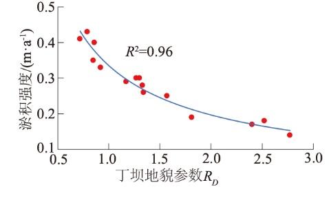
基于构建的丁坝地貌参数RD,对长江口北槽丁坝群坝田初期淤积强度进行了系统的相关性分析。研究结果表明,坝田初期淤积强度与RD之间的决定系数R2达0.96,存在显著的相关性(图8)。
图8 丁坝地貌参数与淤积强度相关性分析

Fig.8 Correlation analysis between spur dike geomorphic parameters and siltation intensity

3.3 坝田淤积强度经验公式的构建

基于前述分析,所构建的综合动力参数能够显著地反映坝田的淤积强度,而量纲一的地貌参数则能有效揭示不同坝田间淤积强度的差异性。进一步地,通过综合动力参数与量纲一的地貌参数,本文提出以下经验公式,即
${P}_{D}=\alpha ({P}_{D}{)}^{\beta {R}_{D}}=\alpha {\left(\frac{QS}{HD}\right)}^{\beta \frac{WL}{{h}_{D}(W+L)}} 。$
式中:α,β均为系数(主要受河口形态影响),α取值建议在0.9~1.1范围内,β取值建议在0.3~0.35范围内。
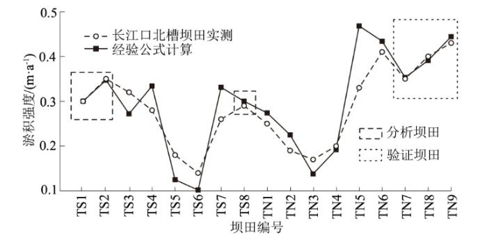
以长江口北槽丁坝群各坝田为例,通过以上经验公式计算各坝田建成后初期淤积强度(α=1,β=0.31)。考虑坝田TS1、TS2、TS8在1999年形成后无其他工程及人类活动影响,接近自然发育状态,因此采用以上坝田的坝田地形实测数据进行拟合分析,通过经验公式计算得到坝田建成后的淤积强度与实测基本一致。此外,采用二期工程2002年形成后同样不受工程和人类活动影响的TN7、TN8、TN9三座坝田进行验证,验证结果显示,采用以上经验公式基本可以反映坝田建成后的淤积强度,验证结果良好(图9)。
图9 坝田淤积强度经验公式验证情况

Fig.9 Verification of empirical formula of siltation intensity in the dike field

TN1—TN5坝田存在分期工程,坝田地貌参数随之改变;而TS3—TN7除了存在分期工程导致坝田地貌参数改变之外,并在S3—S8南坝田间新建一座长约21 km的防沙堤。但通过经验公式计算仍然可以反映出各坝田之间的淤积趋势。
此外通过调整α和β的取值可修正其计算值,使之与实测值一致,因此也同样说明了α和β的取值存在一定的合理性。

4 结论

基于长江口北槽坝田实测数据,以坝田淤积强度为指标,根据物质守恒建立相应的丁坝地貌参数,并研究其与坝田淤积强度的相关性,讨论在丁坝建设初期能够合理布置其形式以及在丁坝形成后确定其坝田的促淤效果。得到以下结论:
(1)随着长江口深水航道治理工程丁坝建设的实施,坝田的总淤积量持续增加,坝田的促淤效果显著。通过分析各坝田相对间距和初始水深与坝田建成后的淤积强度,发现坝田淤积强度受相对间距和初始水深影响显著。TS1和TS2坝田淤积强度对流量、含沙量、潮差、悬沙粒径的响应趋势也较为显著。因此进一步说明长江口北槽丁坝群坝田淤积强度受丁坝平面布置和长江口水沙动力条件的综合影响。
(2)随着大通年均径流的增加,坝田内的泥沙淤积厚度明显增加;随着大通年均含沙量的增加,坝田内的泥沙淤积厚度也明显增加;随着北槽中年均潮差和悬沙粒径的增加,坝田内的泥沙淤积厚度显著减小。在丁坝相对间距≤6时,丁坝相对间距越大,坝田淤积强度越大,但相关性较差;丁坝之间初始水深越大,坝田淤积强度越大,两者基本呈线性相关。
(3)长江口北槽丁坝群TS1和TS2坝田历年泥沙淤积强度与PD相关性显著,决定系数达到0.96,说明通过构建的综合动力参数PD可以进一步有效表征坝田的淤积强度。坝田初期淤积强度与构建的丁坝地貌参数RD之间存在显著的相关性,且两者关系可通过幂函数模型进行定量描述。
(4)基于长江口北槽丁坝群地形实测资料,结合构建的地貌参数提出了河口坝田淤积强度经验公式。长江口比槽坝田建成后的淤积强度与经验公式计算结果基本一致。
[1]
王任超, 张功瑾, 胡彩霞, 等. 潮汐河口丁坝布置对河床冲刷的影响研究[J]. 人民珠江, 2020, 41(1): 63-68.

(WANG Ren-chao, ZHANG Gong-jin, HU Cai-xia, et al. Study on the Effect of Spur Dike Arrangement in Tidal Estuary on River Bed Scouring[J]. Pearl River, 2020, 41(1): 63-68. (in Chinese))

[2]
范蕾. 丁坝群几何参数对支流斜交弯曲干流河道水流的影响[D]. 邯郸: 河北工程大学, 2014.

(FAN Lei. The Influence of Geometric Parameters of Spur Dike Group on the Flow of Oblique Bending Main Stream of Tributaries[D]. Handan: Hebei University of Engineering, 2014. (in Chinese))

[3]
李溢汶, 吴巍巍, 代斌. 低含沙条件下长江口丁坝群冲淤及水动力变化特点[J]. 水运工程, 2025(1): 85-92.

(LI Yi-wen, WU Wei-wei, DAI Bin. Alluvial and Hydrodynamic Characteristics of Spur-dikes under Low Sediment Concentration Condition in the Yangtze River Estuary[J]. Port & Waterway Engineering, 2025(1):85-92. (in Chinese))

[4]
楼亚颖. 长江口开敞型潮滩动力地貌过程研究[D]. 上海: 华东师范大学, 2022.

(LOU Ya-ying. Morphodynamic Processes of the Unsheltered Tidal Flats in the Changjiang Estuary[D]. Shanghai: East China Normal University, 2022. (in Chinese))

[5]
张功瑾, 杨明金, 王任超, 等. 长江口水沙条件对丁坝群坝田淤积的影响研究[J]. 水文, 2020, 40(6): 24-30, 50.

(ZHANG Gong-jin, YANG Ming-jin, WANG Ren-chao, et al. Research on the Influence of Water and Sediment Conditions in Yangtze River Estuary on Deposition in the Fields among Spur Dikes[J]. Journal of China Hydrology, 2020, 40(6): 24-30, 50. (in Chinese))

[6]
金镠. 丁坝群坝田与主流水沙交换与冲淤机理综述[J]. 水运工程, 2019(12): 80-85.

(JIN Liu. View of Mechanism of Water and Sediment Exchange and Sedimentation in Groyne Fields[J]. Port & Waterway Engineering, 2019(12): 80-85. (in Chinese))

[7]
UIJTTEWAAL W S. Effects of Groyne Layout on the Flow in Groyne Fields: Laboratory Experiments[J]. Journal of Hydraulic Engineering, 2005, 131(9): 782-791.

DOI

[8]
WEITBRECHT V, SOCOLOFSKY S A, JIRKA G H. Experiments on Mass Exchange between Groin Fields and Main Stream in Rivers[J]. Journal of Hydraulic Engineering, 2008, 134(2): 173-183.

DOI

[9]
YOSSEF M F M, DE VRIEND H J. Flow Details near River Groynes: Experimental Investigation[J]. Journal of Hydraulic Engineering, 2011, 137(5): 504-516.

DOI

[10]
SANCHEZ-CABEZA J A, PUJOL L. Study on the Hydrodynamics of the Ebro River Lower Course Using Tritium as a Radiotracer[J]. Water Research, 1999, 33(10):2345-2356.

DOI

[11]
SUKHODOLOV A, ENGELHARDT C, KRÜGER A, et al. Case Study: Turbulent Flow and Sediment Distributions in a Groyne Field[J]. Journal of Hydraulic Engineering, 2004, 130(1): 1-9.

DOI

[12]
孙士勇. 上海港宝山作业区港池回淤分析[J]. 水运工程, 1997(12):3-8.

(SUN Shi-yong. Analysis of Siltation in Baoshan Working Area of Shanghai Port[J]. Port & Waterway Engineering, 1997(12): 3-8. (in Chinese))

[13]
孔祥柏, 程年生. 丁、 潜坝局部水头损失的试验研究[J]. 水利水运科学研究, 1992(4): 387-395.

(KONG Xiang-bai, CHENG Nian-sheng. Studies on Local Head Losses of Spur and Submerged Dikes[J]. Hydro-Science and Engineering, 1992(4): 387-395. (in Chinese))

[14]
韩玉芳, 陈志昌. 丁坝回流长度的变化[J]. 水利水运工程学报, 2004(3):33-36.

(HAN Yu-fang, CHEN Zhi-chang. Variation of Re-circulation Length of Spur Dikes[J]. Hydro-Science and Engineering, 2004(3):33-36. (in Chinese))

[15]
PRZEDWOJSKI B, BLAZEJEWSKI R. River Training Techniques:Fundamentals, Design and Applications[M]. Florida: CRC Press, 1995.

[16]
HSU T W, LIN T Y. Effects of Groin Spacing on Beach Morphology[J]. Ocean Engineering, 2004, 31(7):901-921.

DOI

[17]
ELAWADY E, MICHIUE M. Experimental Study on the Effect of Groin Angle on Sediment Transport[J]. Journal of Hydraulic Research, 2001, 39(3):259-266.

DOI

[18]
岳建平. 港渠口门回流淤积概化模型试验和研究[J]. 泥沙研究, 1986, 11(2): 41-50.

(YUE Jian-ping. Experimental Study on the Sediment Deposition Caused by Rotating Flow in the Closed Channel[J]. Journal of Sediment Research, 1986, 11(2): 41-50. (in Chinese))

[19]
谢鉴衡. 关于低水头水利枢纽的河势规划问题[J]. 水利水电技术, 1985, 16(7): 1-8, 62.

(XIE Jian-heng. On River Regime Planning of Low-head Water Control Project[J]. Water Resources and Hydropower Engineering, 1985, 16(7): 1-8, 62. (in Chinese))

[20]
刘青泉. 盲肠河段口门掺混区的泥沙扩散[J]. 泥沙研究, 1995, 20(2): 11-21.

(LIU Qing-quan. A Study on Sediment Diffusion in Turbulent Mixing Region at the Mouth of Cecum Reach[J]. Journal of Sediment Research, 1995, 20(2): 11-21. (in Chinese))

[21]
黄才安, 奚斌. 水流能耗率极值原理及其水力学实例研究[J]. 长江科学院院报, 2002, 19(5): 7-9.

(HUANG Cai-an, XI Bin. Study on Extreme Theories of Energy Consumption and Its Hydraulics Examples[J]. Journal of Yangtze River Scientific Research Institute, 2002, 19(5): 7-9. (in Chinese))

Outlines

/