RIVER-LAKE PROTECTION AND REGULATION

Channel Dimension Improvement for Chenglingji to Wuhan Section in Middle Reach of Yangtze River

  • DENG Liang-ai , 1 ,
  • ZHANG Kang-he , 2 ,
  • JIANG Ling 2, 3 ,
  • LI Lei-lie 2 ,
  • XU Min 2, 3
Expand
  • 1 Technical Service Department, Changjiang Waterway Bureau, Wuhan 430011, China
  • 2 ChangjiangWaterway Survey and Design Institute (Wuhan) Co., Ltd., Wuhan 430011, China
  • 3 ChangjiangWaterway Institute of Planning and Design, Wuhan 430011, China

Received date: 2025-02-24

  Revised date: 2025-04-30

  Accepted date: 2025-05-06

  Online published: 2025-06-03

Abstract

[Objective] The navigation capacity of the Chenglingji-Wuhan section (Chengwu section) in the middle reach of the Yangtze River lags behind the economic development along the river. This study aims to analyze the improvement of channel dimensions to fully utilize the efficiency of this “golden waterway” and better support the socio-economic development along the river. [Methods] Based on the variation characteristics of the Chengwu section under new runoff and sediment conditions, this study utilized nearly a decade of runoff and sediment observation data and navigation charts collected after the discharge from the Three Gorges Project stabilized. A comprehensive verification was conducted on the channel conditions under different channel dimensions across the 22 waterways within the river section. The key challenges in dimension improvement were analyzed, and corresponding governance measures were proposed. [Results] The guarantee rates for the channel dimensions of 6.0 m×200 m and 6.0 m×150 m in the Chengwu section showed little difference. Among the 22 waterways, nine failed to meet the year-round verification criteria. The guarantee rate increased as the channel width decreased. Under the channel dimension of 6.0 m×200 m, the Wuqiao waterway had the lowest multi-year average guarantee rate of 77%, while the rates for the remaining waterways all exceeded 86%. Among the nine problematic waterways, four (Jiepai, Jiayu, Baishazhou, and Wuqiao) failed to meet the 6.0 m×200 m channel dimension during the dry seasons in most years, while the remaining waterways failed only in individual years. The total length of shoal areas accumulated to approximately 8.95 km, accounting for 3.92% of the total length of the river section. Overall, the natural conditions were favorable for increasing the channel depth to 6.0 m. The problematic waterways were mainly of the branching-channel type. Among them, the main issue in the Jiepai, Longkou, Jiayu, and Yanwo waterways was insufficient water depth, whereas for the others, it was primarily narrow channel width. The shoal areas were mainly located at the inlets of branching channels and local widening sections. [Conclusion] Guided by the governance thoughts of “integrating regulation and dredging for comprehensive management”, the improvement of channel dimensions can be achieved by implementing regulation projects to appropriately restrict the flow diversion into branching channels, thereby increasing the hydrodynamic force in the main channel. Additionally, the clear water released from upstream reservoirs should be utilized to scour the river channel. Combined with dredging methods and new intelligent navigation guidance technologies, these measures collectively facilitate the improvement of channel dimensions. Specifically, for the Jiepai waterway, channel regulation should be implemented in phases. Dredging should first be applied to the outlet of the left channel while ensuring the uninterrupted operation of the right channel as the main channel. After the left channel becomes navigable, flow-restricting structures can be constructed in the right channel. For the Jiayu waterway, regulating the central bar to increase the flow-split ratio towards the left branch, coupled with the strategy of narrowing the channel to concentrate flow for sediment scouring, can address local navigation obstructions in the left branch. Regarding the Wuqiao waterway, flow-guiding structures should be deployed at the tail of the Baishazhou bar upstream to direct the main flow from the Baishazhou waterway into the left branch around the submerged bar within the Wuqiao waterway. Additionally, training dikes should be built along the submerged bar. Integrating these with dredging and new navigation guidance technologies will improve the navigation conditions in the bridge area and enhance safety. This study is a preliminary exploration. Further in-depth studies may focus on strengthening the validation of engineering plans through model tests.

Cite this article

DENG Liang-ai , ZHANG Kang-he , JIANG Ling , LI Lei-lie , XU Min . Channel Dimension Improvement for Chenglingji to Wuhan Section in Middle Reach of Yangtze River[J]. Journal of Changjiang River Scientific Research Institute, 2026 , 43(4) : 27 -33 . DOI: 10.11988/ckyyb.20250140

0 引言

随着沿江经济的快速发展,长江已经成为世界运输最繁忙的河流,以长江航运为重要组成部分的长江交通大动脉,已成为沿江经济发展的主通道和长江经济带综合交通运输体系的主骨架,货物通过量连续多年稳居世界内河首位。随着货运需求的持续提升,运输船舶大型化、航线远程化趋势越发明显[1-2],航道尺度需求也逐步提高。长江中游城陵矶至武汉河段(以下简称“城武段”)航道条件复杂,历来是航道维护的重难点所在[3],航道尺度瓶颈提升难度较大,“九五”期间,先后实施多项航道整治工程,加之三峡水库蓄水运用,最小维护水深由2.9~3.2 m提升至4.5 m[4]。但随着中国(湖南)自由贸易试验区的发展,城陵矶港区的水运物流体系和港口基础设施建设不断加速,城武段航道水深不足的问题再次凸显。万吨级集装箱船舶、两万吨级散货船舶枯水期通航的难题仍未解决,上述代表船型的航道水深尺度需求为6.0 m,需对城武段航道尺度提升可能性进行分析。
近年来,对于城武段航道尺度提升至6.0 m的可能性研究较少。有学者从航道承载力的角度进行过分析,如钱红露等[5]基于航道自然禀赋,通过应用考虑了生态等多种外部影响的多目标协同航道承载力评价方法和模型[6],以点代线,进行航道承载力评估,得出以界牌为代表的城武段基于自然禀赋的航道承载力为(9.0~9.5)m×200 m(水深×航宽,下同),多目标协同下的承载力为6.0 m×200 m。单敏尔等[7]基于实测资料,采用稳定航深估算法,分析得出城武段在200 m航宽下基于自然禀赋的最大稳定航深为6.1 m;而后单敏尔等[8]对稳定航深计算方法进行改进,得到城武段150 m和200 m航宽下基于自然禀赋的稳定航深分别为6.0 m和5.6 m(未考虑航道治理)。可见,现有研究认识尚不统一,且针对河段所有水道,通过核查梳理现状,分析治理思路并提出措施的研究尚未出现。
本文以三峡下泄流量基本稳定后的2015—2023年的枯水和中洪水期航道测图以及邻近水文站年内水位过程实测资料为基础,分析了枯水期航道条件以及全年6.0 m航道水深保证率,研究了航道治理思路和措施,可为长江干线航道建设发展提供技术支撑。
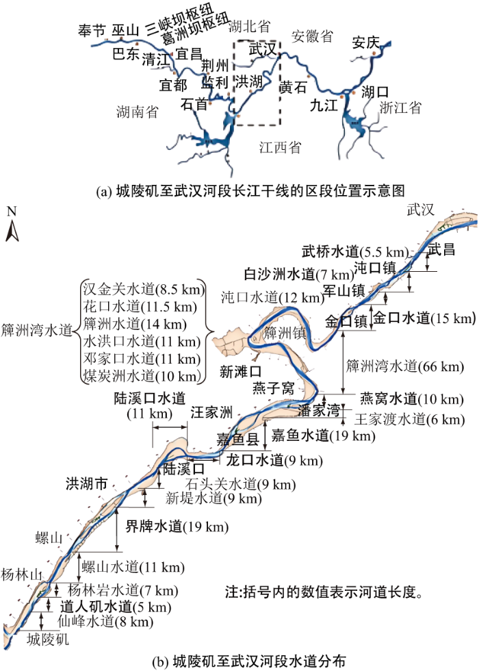
1 河道概况

城武段地处湖北和湖南两省交界,上起岳阳城陵矶,下迄武汉长江大桥,属于冲积平原河段,沙质河床,全长约228.5 km,见图1;河段入口的城陵矶港是湖南省唯一通江达海的水运港口,经济腹地及辐射范围可达湘赣鄂云贵川[9]
图1 长江中游城陵矶至武汉河段河势及重点水道分布

Fig.1 River regime and key waterway distribution from Chenglingji to Wuhan section in the middle reach of Yangtze River

城武段两岸山矶节点较多,也存在多处暗礁,受对峙节点控制,节点处河宽较窄,节点之间河道展宽分汊,平面形态呈藕节状[10]。河段内共有22个水道,除中段的簰洲弯道段为典型弯曲河型外,上段的城陵矶至潘家湾段和下段纱帽山至武汉段均为分汊河段,且以顺直分汊为主[11]。河段内重点存在界牌、嘉鱼、白沙洲、武桥等浅滩碍航水道。

2 水沙特性

城武段承接荆江河段来水和洞庭湖水系,出口左岸又有中游最大支流汉江入汇;沿程主要分布有螺山、汉口2个水文站,其中螺山站为洞庭湖入汇长江以后的第一个水文站,为江湖关系控制站;汉口水文站为长江接纳洞庭湖水系及汉江后的控制站。本文以螺山、汉口站为代表站分析城武段水沙特性。
图2为城武段涉及的主要水文站在三峡工程运用前后的水沙过程。由图2可见,三峡水库蓄水运用改变了年内径流过程,螺山站和汉口站的径流量虽年际间因丰枯水年存在波动,但长时间序列总体趋平,至2022年螺山站和汉口站年均径流量较蓄水前分别减少4%和3%,三峡水库蓄水运用对城武段径流量的影响总体不大。
图2 城武段主要水文站径流量和输沙量变化情况

Fig.2 Changes in runoff and sediment transport at major hydrological stations in Chengwu section

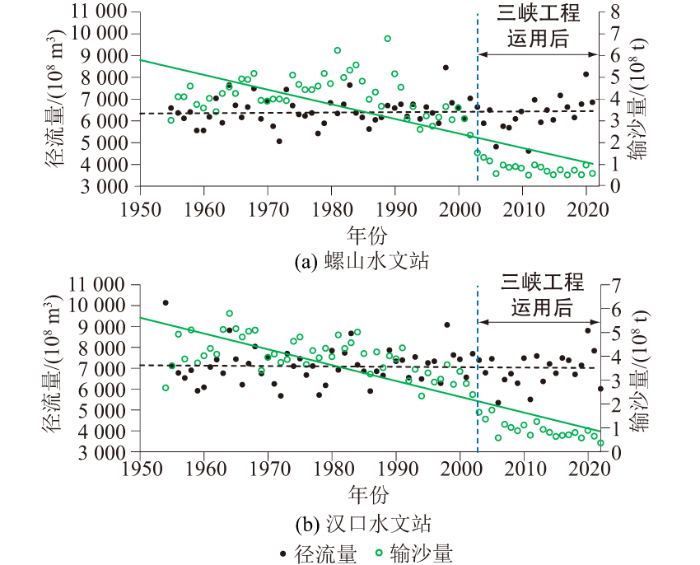
三峡水库蓄水运用以后,下泄沙量明显减少,由于沿程床沙补给不足,至2022年螺山站和汉口站年均输沙量较蓄水前的减幅分别为80%和77%;且三峡水库蓄水以来年际间输沙量总体继续呈减小态势,主要与上游向家坝、溪洛渡等梯级水库的陆续运行进一步减小沙源有关。

3 航道特点及现状

三峡水库蓄水以后,坝下的来水来沙过程均发生变化,“清水下泄”导致坝下河段出现普遍冲刷[12]。对于洲滩边界稳定、洪枯流路一致的水道,清水冲刷刷深枯水河槽,航道水深向有利方向发展;对于岸线、江心洲以及边滩稳定性较差以及洪枯流路不一致的水道,河床冲刷又会带来河道展宽出浅、主流摆动幅度增大等不利影响。
为打造长江干线黄金水道,逐步提升长江航道的通过能力,“九五”至“十三五”期间,城武段先后在杨林岩、界牌、嘉鱼、燕窝、武桥共5个水道实施了7项航道整治工程。通过因势利导及时稳定汊道分流态势,局部调整不利滩槽形态,并适当控制滩槽不利变化,城武段最小维护水深由2.9 m逐步提高至4.0 m。“十四五”期间,充分利用三峡工程清水冲刷,不断加大维护疏浚力度,如2017—2020年、2021—2023年期间的年均维护疏浚量分别为94万、306万m3,初步实现了4.5 m最小维护水深。
根据2023年长江航道局公布的城武段分月维护水深计划,最小分月维护水深已达4.5 m。对于6.0 m水深情况,从分月计划维护尺度来看,洪水期的6—8月最小维护尺度也已提升至6.0 m,具体见表1
表1 长江中游城武段航道2023年分月维护水深计划

Table 1 Monthly maintenance water depth plan for channels of Chengwu section in the middle reach of Yangtze River in 2023

月份 1 2 3 4 5 6 7 8 9 10 11 12
水深/m 4.5 4.5 4.5 4.5 4.5 6.0 6.0 6.0 5.5 4.5 4.5 4.5

注:6—9月试运行。

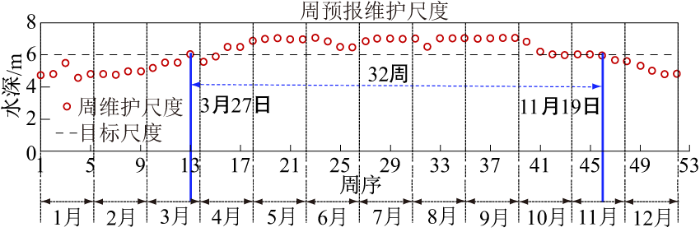
2022年和2023年均为特殊水情年,以2021年城武段的分周预报的维护尺度数据分析6.0 m尺度的实际维护情况,城武段位于6.0 m水深临界线及以上的时间从3月27日持续至11月19日,长度可达32周,已经实现中水期、洪水期全保证,其中5—9月份水深已接近7.0 m,可见,非特殊水情年6.0 m水深的实际维护时长更长(图3)。
图3 城武段2021年周预报维护尺度情况

Fig.3 Weekly forecast and maintenance dimensions of Chengwu section in 2021

4 航道条件核查分析

4.1 核查方法

长江干线武汉至安庆河段航道最小维护尺度已提高至6.0 m×200 m,三峡船闸预期可实现万吨级船舶通航,考虑与上下游航道尺度衔接,提升长江干线航道整体效益,结合城武段自然水深条件,确定航道水深核查标准为6.0 m。
核查航宽的确定分别考虑单船单向、单船双向等不同提升难度和通航需求,依据《长江干线通航标准》计算得到22 m宽船舶单船单向、单船双向的航宽需求分别为51 m和105 m,因此单船单向航宽取60 m,单船双向航宽取110 m。考虑通航安全,将单船双向的航宽拓宽至150 m,进一步考虑上下游航道尺度衔接将航宽拓展至200 m。由此确定此次航道条件核查的航宽分别为60、110、150、200 m。
2015年以后三峡下泄流量基本稳定,故采用2015—2023年的枯水和中洪水期航道测图以及邻近水文站年内水位过程进行航道条件核查,核查的范围涵盖城武段22个水道,重点核查近年来滩槽稳定性较差的浅滩碍航水道。由于沙质河段河床地形年内冲淤变化较大,需分别对枯水期和中洪水期进行航道条件核查,得到不同时期的最不利水深,进而得到6.0 m水深贯通所需水位,结合就近站点年内水位过程,得到6.0 m水深保证率。

4.2 保证率核查分析

从全年6 m×200 m、6.0 m×150 m航道尺度的保证率来看,2种标准核查结果相差不大,2015—2023年无法全年满足核查标准的有9个水道,包括道人矶、界牌、陆溪口、龙口、嘉鱼、燕窝、金口、白沙洲、武桥等水道。其中,武桥水道航道尺度保证率最低,年均保证率为77%,保证天数281 d;其他8个水道年均保证率超过86%,保证天数超317 d,主要表现为枯水期航道尺度不足(见图4)。
图4 城武段各个水道不同航道尺度贯通情况

Fig.4 Duration of connectivity under different channel dimensions in different waterways of Chengwu section

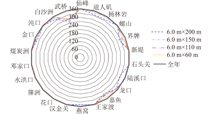
从全年6.0 m×60 m航道尺度的保证率来看,2015—2023年有5个水道无法全年满足6.0 m×200 m航道尺度,包括道人矶、界牌、龙口、嘉鱼、武桥等水道。其中,武桥水道航道尺度年均保证率最低,为82%,保证天数300 d;其他4个水道航道尺度年均保证率超过95%,保证天数超348 d。
总体来看,按照核查航道尺度标准,城武段6.0 m×200 m与6.0 m×150 m的航道尺度保证率相差不大,9个水道不能全年达到核查标准,随着航宽减小,航道尺度保证率有所提高。城武段22个水道除武桥水道年均保证率约为80%,其他水道保证率均超过86%,具备航道尺度提升的基础条件。

4.3 枯水期航道条件现状

经核查,城武段无法全年满足6.0 m×200 m航道尺度,9个水道中,界牌、嘉鱼、白沙洲和武桥等4个水道为多数年份无法满足目标尺度,道人矶、杨林岩、陆溪口、龙口、燕窝和金口等5个水道为个别年份无法满足目标尺度,其他尺度情况详见表2
表2 城武段主航道可维持尺度核查

Table 2 Verification of main channel maintainable dimensions from Chenglingji to Wuhan section

序号 重点
水道
不同尺度核查结果
6.0 m×
200 m
6.0 m×
150 m
6.0 m×
110 m
6.0 m×
60 m
1 道人矶
2 界牌
3 陆溪口
4 龙口
5 嘉鱼
6 燕窝
7 金口
8 白沙洲
9 武桥

注:“○”表示常年可以维持此航道尺度(0);“◎”表示个别年份不能维持此航道尺度(0~70%);“●”表示多数年份不能维持此航道尺度(≥70%)。

界牌、龙口、嘉鱼、燕窝水道的航道问题主要是水浅,其他水道主要为航宽较窄。统计各浅水道浅区长为8.95 km,占河段总长3.92%,浅区主要位于汊道进口及局部放宽段,详见表3
表3 城武段航道尺度不足6.0 m×200 m的浅区统计

Table 3 Statistics of shallow areas with channel dimensions less than 6.0 m × 200 m in Chengwu section

序号 重点水道 浅区长度/m 最小水深/m 浅区位置
1 道人矶 300 4.2 磨盘石及其附近
2 界牌 3 000 4.1 左汊出口处、
上荷叶洲过河浮标处
3 陆溪口 200 5.6 直港进口处
4 龙口 450 5.3 龙口3#白浮附近
5 嘉鱼 2 000 4.6 复兴洲左汊进口、
三矶头附近
6 燕窝 1 200 5.1 左汊进口处
7 金口 600 4.8 铁板洲右汊,金口河口处
8 白沙洲 500 5.4 白沙洲左汊进口
9 武桥 700 4.7 汉阳边滩、潜洲进口处

注:表中浅区长度为水道不贯通年份中问题最大年份的数据。

5 航道尺度提升治理

5.1 航道尺度提升技术难点

对于枯水期航道尺度多数年份无法满足6.0 m×200 m的界牌、嘉鱼、白沙洲和武桥4个水道中,白沙洲水道主要受白沙洲心滩头部低滩和出口左侧荒五里边滩不稳定影响,6.0 m航槽宽度不足,治理难度不大;界牌、嘉鱼和武桥水道则是治理的难点所在,为本河段治理的重点碍航水道。
界牌水道目前右槽分流比约70%,为现行主航槽,但进口呈逐渐淤浅的不利趋势,养护4.5 m水深航道的压力较大。总结分析历年河势变化中过渡形式较好的航路,并结合航道演变趋势,左槽更适合河道自身发展,过渡形式也更稳定,但左槽冲刷发展较慢,因此存在治理时机选择的难题。
嘉鱼水道以左汊为主汊道,但近期分流比有所减小,航道尺度提升需适当限制嘉鱼中夹的流量,以增大左汊的流量。由于该水道分布有长江新螺白鱀豚国家级自然保护区,航道治理的关键是协调解决好环境影响问题。武桥水道的深槽与桥梁设计通航桥孔不一致,加上城区河段复杂外部条件的限制,治理难度较大。
此外,城武段是水利防洪的重点区域,险工、险段众多,沿江还密布取水口、码头、锚地、过江电缆及穿江管线等涉水设施,部分水道还可能涉及自然保护区,制定既满足航道要求、又对周边环境影响较小的治理方案难度较大。

5.2 航道尺度提升治理思路及措施

基于上述分析以及以往治理经验,若将城武段提升至6.0 m×200 m,需采取“整疏结合、综合治理”的治理思路。三峡工程清水下泄条件下,沙质河床可通过关键洲滩的守护或调整,来稳定或塑造有利滩槽格局,控制汊道分流,同时结合疏浚加大主航道中枯水航槽冲刷,提高航道尺度。而且,航道整治需要与生态涵养、修复相融合[13-15]
界牌、嘉鱼和武桥3个重点碍航水道的治理思路如下:
(1)界牌水道为顺直分汊河段,左槽由水流切割左岸边滩形成,为中洪水流路,呈缓慢冲刷发展态势,当前,中上段水深较好、出口水深不能达到6.0 m;而右槽虽为主汊,但因受中洪水上游边滩淤积下延、枯水冲刷动力不足,外加右侧丁坝群工程对右槽展宽的限制,在近期每年进行枯水疏浚养护的条件下,仍有所淤积萎缩,见图5(a)。鉴于界牌水道两槽当前水深条件均较差,为不影响通航,航道治理宜分步实施,在保障右槽主航道不断航的前提下,先疏挖左槽出口,使其逐步具备通航水深条件;待左槽具备通航条件,再通过延长右岸已有丁坝加速右槽萎缩,加快左槽分流比的增加,增大左槽水动能,使得左槽得以冲刷发展,有可能实现并维持6.0 m水深。
图5 界牌河段和嘉鱼水道水深分布云图

注:水深云图仅展示重点区域,下同。

Fig.5 Contours of water depth distribution in Jiepai and Jiayu waterways

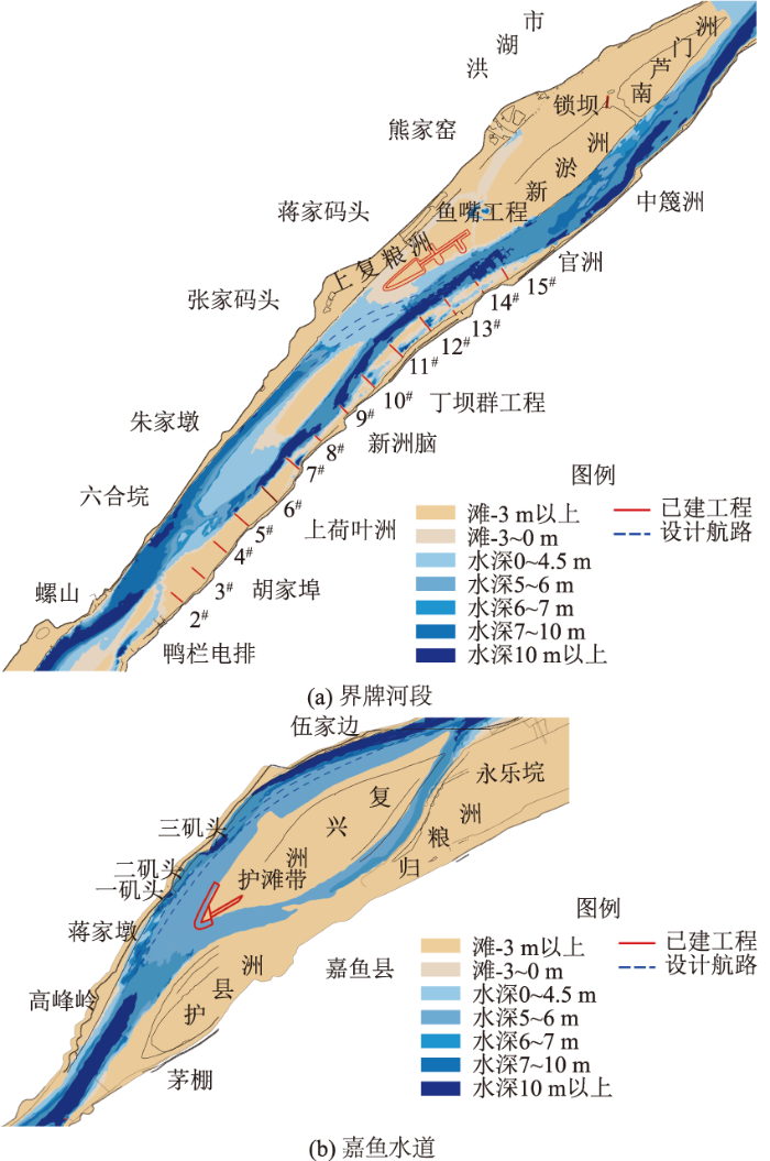
(2)嘉鱼水道为微弯放宽分汊河型,左汊为主汊,枯水期分流比约62%,但受分流区主流右偏的影响,中夹呈发展态势,见图5(b)。由于中夹分布有自然保护区核心区,嘉鱼水道的治理需在深入论证施工期临时调整保护区功能的基础上,通过限制中夹,增大左汊分流比,调整汊道分流格局;局部束水攻沙,改善左汊航道水深,并采取生态补偿措施,左汊有可能实现并维持6.0 m水深。
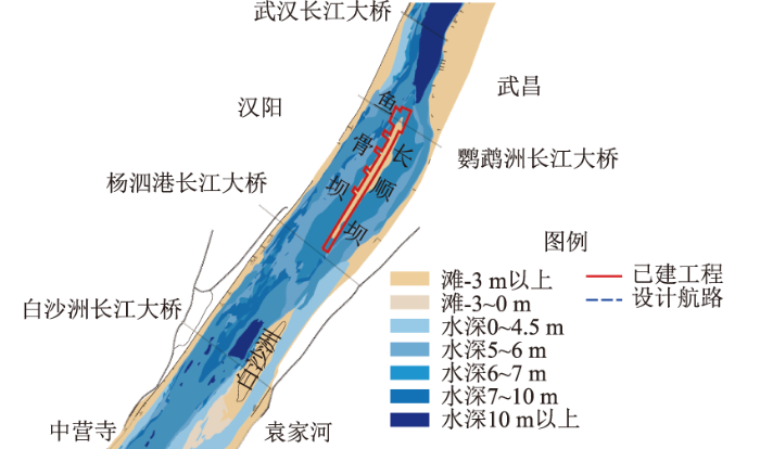
(3)武桥水道的航道问题主要是出口处武汉长江大桥通航设计桥孔安全通航问题,这与汉阳边滩的发育程度密切相关。当汉阳边滩淤积,滩咀深入设计通航桥孔及其上游航道,导致航路弯曲,航路走向与桥墩纵轴线形成的夹角较大时,造成设计通航孔无法通航,被迫改用非设计通航孔通航,见图6。由于汉阳边滩的冲淤变化又与该河段的水动力特性密切相关,武桥水道的治理可通过增强潜洲左汊水动力,如在白沙洲洲尾布设导流工程引导更多水流进入潜洲左汊、加高潜洲促使水流提前归槽,集中水流加大对汉阳边滩的冲刷,同时结合疏浚改善桥区航道条件,武桥水道有可能实现6.0 m水深。此外,通过在桥区建立全要素感知网络,基于电子航道图实现船舶安全智能导助航[16],同时加强船桥避碰新技术应用,如激光雷达视频跟踪防碰撞预警系统等[17-18],提高通航保障。
图6 武桥水道水深分布云图

Fig.6 Contours of water depth distribution in Wuqiao waterway

6 结论

(1)城武段6.0 m×200 m与6.0 m×150 m的航道尺度保证率相差不大,22个水道中有9个水道不能全年达到核查标准,且随着航宽减小,航道尺度保证率有所提高;其中,除武桥水道年均保证率约为77%(不足80%)外,其他水道保证率均超过86%,具备航道尺度提升的基础条件。
(2)界牌、嘉鱼、白沙洲和武桥等4个水道为多数年份枯水期无法满足6.0 m×200 m航道尺度,道人矶、陆溪口、龙口、燕窝和金口等5个水道为个别年份枯水期无法满足6.0 m×200 m航道尺度。其中,界牌、龙口、嘉鱼、燕窝水道的航道问题主要是水浅,其他水道的航道问题主要为航宽较窄。浅水道浅区总长为8.95 km,占河段全长3.92%,浅区主要位于汊道进口及局部放宽段。
(3)城武段采取“整疏结合、综合治理”的治理思路。针对界牌、嘉鱼和武桥3个重点碍航水道,提出治理措施。其中界牌水道航道治理宜分步实施,在保障右槽主航道不断航的前提下,先疏挖左槽出口,待左槽具备通航条件后,实施右槽限制工程。嘉鱼水道通过限制中夹,增大左汊分流比,同时束水攻沙,解决左汊局部碍航问题,并采取生态补偿措施。武桥水道通过在上游白沙洲洲尾布设导流工程,引导白沙洲水道主汊出流进入武桥水道潜洲左汊,并在潜洲修建顺导流工程,结合疏浚改善桥区航道条件,同时配合应用导助航新技术,提高通航安全保障。
上述研究仅为初步探讨,建议后续开展深入研究,加强工程方案模型试验论证。
[1]
姜伟. 内支线集装箱船发展趋势[J]. 中国水运, 2022(2): 109-110.

(Jiang Wei. Development Trend of Inner Branch Container Ship[J]. China Water Transport, 2022(2): 109-110. (in Chinese))

[2]
李文杰, 杨宁, 杜洪波, 等. 长江上游船舶大型化对典型污染排放的影响[J]. 水运工程, 2022(2):100-105.

(Li Wen-jie, Yang Ning, Du Hong-bo, et al. Impact of Ship Enlargement on Typical Pollution Emissions in the Upper Yangtze River[J]. Port & Waterway Engineering, 2022(2): 100-105. (in Chinese))

[3]
江凌. 长江中游宜昌至武汉河段航道建设思路探讨[J]. 水运工程, 2014(12):116-121.

(Jiang Ling. Ideas on Channel Regulation for Yichang to Wuhan Reach[J]. Port & Waterway Engineering, 2014(12):116-121. (in Chinese))

[4]
Zhang X, Yang Y, Li M, et al. Waterway Channel Stability and Management Measures of Chenglingji-Wuhan Reaches in the Middle Section of the Yangtze River[J]. Water, 2023, 15(11):2047.

DOI

[5]
钱红露, 程稳, 尹维清, 等. 多目标协同下长江航道承载力研究: Ⅱ.应用[J]. 应用基础与工程科学学报, 2022, 30(6): 1366-1376.

(Qian Hong-lu, Cheng Wen, Yin Wei-qing, et al. Research on Waterway Carrying Capacity of the Yangtze River under Multi-objective Cooperation: Ⅱ. Application[J]. Journal of Basic Science and Engineering, 2022, 30(6): 1366-1376. (in Chinese))

[6]
程稳, 钱红露, 尹维清, 等. 多目标协同下长江航道承载力研究:I.理论[J]. 应用基础与工程科学学报, 2022, 30(5):1061-1070.

(Cheng Wen, Qian Hong-lu, Yin Wei-qing, et al. Research on Waterway Carrying Capacity of the Yangtze River under Multi-objective Cooperation: I. Theory[J]. Journal of Basic Science and Engineering, 2022, 30(5): 1061-1070. (in Chinese))

[7]
单敏尔, 雷雪婷, 刘鑫, 等. 长江城陵矶—武汉河段航道最大稳定航深研究[J]. 水运工程, 2023(11):94-98,113.

(Shan Min-er, Lei Xue-ting, Liu Xin, et al. Maximum Stable Channel Depth of Chenglingji to Wuhan Section of the Yangtze River[J]. Port & Waterway Engineering, 2023(11): 94-98, 113. (in Chinese))

[8]
单敏尔, 刘鑫, 李瀛, 等. 长江中游城陵矶—武汉河段稳定航深计算方法改进[J]. 长江科学院院报, 2024, 41(6): 91-97.

DOI

(Shan Min-er, Liu Xin, Li Ying, et al. Improvement of the Calculation Method for Stable Navigation Depth of Chenglingji-Wuhan Section in the Middle Reach of Yangtze River[J]. Journal of Changjiang River Scientific Research Institute, 2024, 41(6): 91-97. (in Chinese))

[9]
李聪. 城陵矶港矿石物流模式优化及协同技术研究[D]. 北京: 中国铁道科学研究院, 2022.

(Li Cong. Optimization of Mineral Supply Chain Mode and Collaborative Resach in Chenglingji Port[D]. Beijing: China Academy of Railway Sciences, 2022. (in Chinese))

[10]
You X Y, Tang J W, Zhang X F, et al. The Mechanism of Barrier River Reaches in the Middle and Lower Yangtze River[J]. Journal of Geographical Sciences, 2017, 27(10): 1249-1267.

DOI

[11]
刘雨晨, 夏军强, 周美蓉, 等. 三峡建库后长江中游江心洲滩面积调整特点[J]. 泥沙研究, 2023, 48(3): 30-37.

(Liu Yu-chen, Xia Jun-qiang, Zhou Mei-rong, et al. The Variations in Exposed Area of Mid-channel Bars in the Middle Yangtze River after the Operation of the Three Gorges Project[J]. Journal of Sediment Research, 2023, 48(3): 30-37. (in Chinese))

[12]
李咏梅, 孙治国, 贾方方. 长江城汉河段深泓线演变对水沙异变的响应研究[J]. 人民长江, 2022, 53(8): 9-14.

(Li Yong-mei, Sun Zhi-guo, Jia Fang-fang. Responses of Thalweg Evolution to Water-sediment Variation in Chenglingji-Hankou Reach of Changjiang River[J]. Yangtze River, 2022, 53(8): 9-14. (in Chinese))

[13]
陈玥如. 长江中游荆江河段绿色航道建设的实践与思考[J]. 长江技术经济, 2021, 5(2): 51-53.

(Chen Yue-ru. Practice and Reflection on Green Waterway Construction on Jingjiang River Section in the Middle Reaches of Yangtze River[J]. Technology and Economy of Changjiang, 2021, 5(2): 51-53. (in Chinese))

[14]
Li T, Ding Y, Xia W. An Integrated Method for Waterway Health Assessment: A Case in the Jingjiang Reach of the Yangtze River, China[J]. Physical Geography, 2018, 39(1): 67-83.

DOI

[15]
李明. 河流心滩守护中的生态固滩方法研究: 以长江倒口窑心滩植入型生态固滩工程为例[J]. 中国农村水利水电, 2018(7): 78-83.

(Li Ming. Research on the Ecological Shoal Consolidation Methods in River Central Bar Protection: Taking the Implantable Ecological Shoal Consolidation Engineering in Yangtze River Daokouyao Channel Bar as an Example[J]. China Rural Water and Hydropower, 2018(7): 78-83. (in Chinese))

[16]
潘荣友, 钟庆云, 梁昱, 等. 关于广西智慧航道建设方案的探讨[J]. 珠江水运, 2024(14):91-93.

(Pan Rong-you, Zhong Qing-yun, Liang Yu, et al. Discussion on the Construction Scheme of Guangxi Smart Channel[J]. Pearl River Water Transport, 2024(14):91-93. (in Chinese))

[17]
吕霞, 邓烨. 北江高等级航道防范船舶碰撞桥梁对策分析[J]. 珠江水运, 2022(1): 78-80.

( Xia, Deng Ye. Countermeasure Analysis of Preventing Ships from Colliding with Bridges in Beijiang High-grade Waterway[J]. Pearl River Water Transport, 2022(1): 78-80. (in Chinese))

[18]
刘祥, 包颖炜, 陈叶凯, 等. 基于视觉识别与毫米波雷达的桥梁防撞预警方法[J]. 机械制造, 2021, 59(9):30-35,40.

(Liu Xiang, Bao Ying-wei, Chen Ye-kai, et al. Prewarning Approach for Bridge Collision Avoidance Based on Visual Recognition and Millimeter Wave Radar[J]. Machinery, 2021, 59(9): 30-35, 40. (in Chinese))

Outlines

/