

开放科学(资源服务)标识码(OSID): 
0 引言
河流与湖泊是支撑人类生产生活的内陆地表水资源载体,同时也是地球表层各圈层运动作用的重要节点,对于生态环境保护具有重大意义。在气候变暖和人类活动加剧的背景下,以河湖水系为主要代表的内陆水体在数量、形态等方面发生了重大变化。河流的形态特征受流量、泥沙输运等因素作用而不断变化,及时观测河道形态特征,监测河流形态演变趋势对于生态保护和防灾减灾具有重要意义[1]。湖泊与自然界的物质和能量循环密切相关,它的形成和消失、扩张和收缩以及其生态环境的变化是地质构造事件与气候事件复杂的相互作用结果,可以反映区域气候变化和环境变化。位于偏远地区的河湖受人类活动直接影响较小,可以更加准确地反映气候变化带来的影响,但传统野外调查监测方法需要耗费大量人力与资源,难以获得高时空分辨率的监测数据。为实现社会经济和生态系统的可持续、高质量发展,对于大型河湖水系的研究不仅应当关注其局部的复杂的相互作用,还应当考虑整体性的河湖管理问题,这也对河湖的系统性监测提出了要求。
遥感技术具有覆盖范围广、可频繁重访和测量成本低的特点,在21世纪初即有研究讨论了将其应用于河湖水资源保护与管理[2]。美国陆地卫星(Landsat)、中分辨率成像光谱仪(Moderate-resolution Imaging Spectroradiometer, MODIS)以及欧洲哨兵卫星(Sentinel)等大量开放遥感数据使得研究者可以在高时空分辨率下对从局部到全球的所有地理尺度进行河湖演变研究[3-4]。光学传感器观测易受云层影响,而主动和被动微波传感器可以透过云层和植被覆盖观测河湖等水体。机载航天遥感提供了早期的高精度观测影像,而无人机遥感可以克服卫星成像的固有限制,提供高时空间分辨率的精确监测,同时无人机图像的运动结构恢复技术以较低的成本提供了与机载激光雷达相近的精度水平,并且可以更加频繁地使用,基于无人机的遥感水文站技术逐渐实用化[5]。应用单一来源遥感影像难以避免其局限性,越来越多的研究开始采用多源遥感数据复合的方式开展[6-7]。得益于长期的遥感卫星数据开放、逐渐强大的计算机以及云计算的出现,遥感技术在河湖演变研究中的应用正在不断深化。与此同时,已有学者分别针对基于遥感的某些河湖特征或类型的研究进行了梳理,对河湖特征的监测包括流量反演[8]、河道监测[9]、水质监测[10]等,对河湖类型的研究包括游荡型河流[1]、分汊型河流[11]等。然而已有的研究集中在遥感技术监测某一项河湖特征的应用情况,较少系统性梳理河湖演变遥感研究的发展现状和技术内在特点。
本文基于中国知识基础设施工程(China National Knowledge Infrastructure, CNKI),对应用遥感技术对河湖的形态监测与水体监测(包括径流监测、水沙监测、水位监测、水面监测与水量估算)方面的研究进行文献计量分析,重点讨论在中国范围内的研究文献数量时序分布、研究区域分布与使用的传感器、研究方法的变化,总结遥感技术在中国河湖演变与保护治理中的应用热点与发展趋势,并与WOS(Web of Science )核心数据库中2014—2023年相同主题文献进行比较,分析近年来全球河湖演变的遥感技术应用现状、研究热点和发展趋势。
1 文献来源
利用CNKI数据库高级检索工具,按“SU1”∩“SU2”的检索方式检索中文核心期刊,包含SCI、EI、CSCD来源期刊,SU代表主题。其中SU1=(“江”or“河”or“湖”)and“遥感”,SU2分别为“演变”“冲淤”“水沙”“浊度”“主槽”“河相”“崩岸”“河势”“萎缩”“扩张”“湿地”“消落带”“连通性”“无人机”“水资源”“径流变化”“流量变化”“水位变化”“水域变化”“水体变化”“高分影像”“航空摄影”“倾斜摄影”“贴近摄影”“高光谱遥感”共25个主题。为与近年来全球河湖演变的遥感应用发展情况与最新成果相比较,利用WOS数据库Advanced search检索工具对核心数据库近10 a相同主题文献进行检索,检索方式如下:(TS=(((morphology OR morphological OR riverbed OR inundation frequency OR water volume OR water body OR connectivity OR UAV OR oblique photogrammetry OR nap-of-the-object photogrammetry OR hyperspectral) AND (change OR dynamics)) AND (lake OR river)) AND TS=(remote sensing OR earth observation))。按照如上方式进行检索,并剔除与“河湖演变”主题无关的文献,最终选择CNKI数据库中284篇文献、WOS数据库中2014—2023年共745篇文献。
2 结果分析
2.1 文献量时序分布
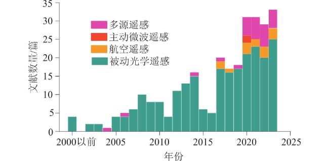
分别绘制在CNKI数据库、WOS数据库检索到的文献数量时序分布图,如图1所示。2000年以前,CNKI数据库中利用遥感技术进行河湖演变研究的文献共有4篇。自2002年起,利用遥感技术进行河湖演变研究的文献数量波动上升,2023年达到顶峰,年文献数量为33篇。自2018年起,WOS数据库检索文献数量增加较为稳定,2020—2022年期间文献数量达到顶峰。

2.2 关键词共现分析
关键词是作者标明的文献内容重点,在长时间同一研究领域中多次重复出现的关键词可以揭示该领域内研究内容的共性、特征及热点方向。利用VOSviewer软件,分别对在CNKI和WOS检索到的文献绘制关键词聚类图谱,由于“遥感(remote sensing)”一词权重较大,为使结果更加直观,不显示“遥感(remote sensing)”的关键词词条,结果如图2所示。
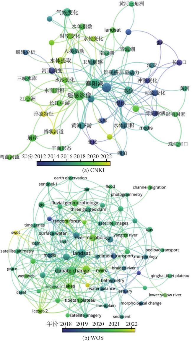
如图2(a)所示,选择关键词出现次数4次及以上,共得到51个关键词,分为9个聚类。共现关键词由“湿地”“河道演变”“冲淤变化”等发展到“形态特征”“水文连通性”“辫状河道”等。共现关键词的这一变化表明随时间变化,在利用遥感技术进行河湖演变的研究中,对河湖特征的分类逐渐精细,对特征量化的精度逐渐提升。在共现关键词中出现的热点研究对象包括:“鄱阳湖”“博斯腾湖”“青海湖”“南四湖”“洪泽湖”“三峡水库”“黄河三角洲”“珠江河口”。对WOS检索到的2014—2023年文献进行同样的分析。该组文献数量更多,选择出现次数5次及以上关键词,共得到66个,分为8个聚类,结果如图2(b)所示。最早的共现关键词为“wetland”和“sediment transport”,最新的共现关键词为“Surface Water and Ocean Topography(SWOT)”“human activities”“river morphology”“bank erosion”与“google earth engine”。
2.3 研究应用的遥感类型
按平台分类将在CNKI中检索到的文献所应用的遥感类型分为航空遥感与航天遥感,对应用航天遥感的研究进一步分类为主动光学遥感、被动光学遥感、主动微波遥感和被动微波遥感。对应用多源遥感的研究单独分类进行统计,在统计的文献中激光雷达遥感或被动微波遥感均与其他类型遥感共同使用,因此归类于多源遥感中,结果如图3所示。
仅使用被动光学遥感进行河湖演变与保护研究的文献数量最多,自2017年起几乎每年均有使用航空遥感开展的河湖演变研究,并且多源遥感得到广泛应用。在全部文献中,应用了被动光学影像的研究占比约94%,应用主动微波影像、航空遥感影像的研究均占比约6%,应用激光雷达遥感的研究占比约2%,应用被动微波影像的研究占比约1%。进一步统计研究中所使用的遥感数据来源,结果如图4所示。
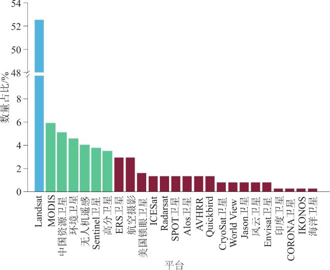
由图4可知,研究应用的遥感平台统计分析表明,Landsat卫星数据在研究中的应用最多,MODIS、中国资源卫星、环境卫星、Sentinel卫星、高分卫星等平台数据也得到了广泛的应用。Landsat卫星数据提供了最长时间序列的高精度数据,该系列卫星数据在占比约一半的研究中得到了应用。随着河湖演变研究与保护治理对遥感影像分辨率需求日益增强,综合考虑不同遥感平台在高清影像解译上的优势,越来越多的研究选择利用多源遥感影像数据提高时间分辨率和空间分辨率。
2.4 各研究区域遥感技术应用分析
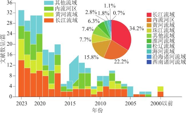
将在CNKI检索到的文献中的研究区域分类覆盖全国范围的长江流域、黄河流域、珠江流域、淮河流域、海河流域、松辽流域、西南诸河流域、沿海诸河流域、内流河区共9个类别,研究区域位于国外或研究区域涉及了多个流域的研究分入其他类别,结果如图5所示。
图5展示了研究区域在各流域中的占比随时间的变化,2020年研究文献数量达到最高且变化趋于稳定后,长江流域的研究文献数量同样趋于稳定。在所有文献中,研究区域位于长江流域的数量最多,其次为内流河区、黄河流域、珠江流域和淮河流域。按研究区域所属流域总结热点流域研究结果,分述如下。
2.4.1 长江流域
长江流域作为中国第一大流域,受长期以来的自然条件变化、河道整治与干支流调蓄工程运行等影响,其干支流演变情况受到研究者的广泛关注。万智巍等[12]结合历史地形与遥感影像研究了85 a来长江荆江河道演变,结果表明由于大规模治理,荆江河段分维下降,演变过程趋于稳定。利用遥感影像反演水下地形进行冲淤变化分析的研究较早在长江流域开展。张东等[13]采用多因子非线性模型反演水下地形并分析了长江口南支河段冲淤变化与水下地形演变情况,表明该河段总体以冲刷为主。大量研究关注了三峡工程运行后河湖演变趋势的变化。薛兴华等[14]以2002年三峡工程运行前荆江段河湾平面为参照,研究了至2015年河湾形态特征演变特征,发现下荆江段河湾形态特征变化程度大于上荆江段。刘雨晨等[15]研究了三峡工程运行后长江中游江心洲变化,发现其出露面积逐渐减少,高滩与低滩冲淤模式有所不同。贺秋华等[16]利用高分卫星、中巴资源卫星等多平台遥感数据分析了三峡工程运行对洞庭湖水量的影响,研究表明三峡水库运行后洞庭湖低枯水位出现时间提前,年平均水面面积与湖容减少。
鄱阳湖和洞庭湖分别是我国第一大和第二大淡水湖,并且都与长江保持自然连通,具有复杂的河湖关系。对长江流域湖泊的研究中,以鄱阳湖作为研究对象的文献数量最多,以洞庭湖作为研究对象的文献数量次之。位于长江流域下游的太湖流域人口稠密、河网密布,王冬梅等[17]基于多源遥感影像分析了自1960年来太湖、滆湖和长荡湖的时空演变规律,结果表明3个湖泊水域面积长期波动,其演变特征具有明显的空间差异,湖泊面积减少主要受人类活动影响。对长江流域湖泊演变的研究分别向长时间序列和高时间分辨率2种趋势发展。余姝辰等[18]利用航空摄影照片、“锁眼”军事卫星图像等资料研究了80 a来洞庭湖垸内湖泊面积变化与演变的空间特征,发现洞庭湖垸内湖数量经历“增-减-增”三阶段变化,整体湖泊数量与面积有所增加。李冰等[19]研究了鄱阳湖80 a来的演变过程,结果表明长期以来鄱阳湖湿地面积下降且主要向耕地转变,其水文连通性下降加剧了鄱阳湖湿地面积的衰减。乐颖等[7]通过光学遥感与微波遥感结合提高了河湖演变监测的时间分辨率。对于观测数据较少的长江源区湖泊,越来越多的研究利用遥感影像进行长期变化研究[20]。
2.4.2 内流河区
以激光雷达卫星、合成孔径雷达卫星为代表的主动遥感技术在内流河区的河湖演变研究中得到了广泛应用。主动遥感不仅可以减弱云层干扰、提供更高时间分辨率的遥感影像,也可以利用测高技术提取水位信息进行水位、水量变化分析[7]。张玉杰等[25]结合卫星激光测高、微波雷达测高与光学影像数据分析了巴尔喀什湖水位变化规律,发现自1970年以来该湖水位先下降后上升并伴随周期性波动,1 a内春季平均水位最高而秋季最低。王晓飞等[26]利用多源微波雷达数据与光学影像研究了伊塞克湖自1960年来多种湖泊特征因素的变化规律,发现湖泊水位与面积先降低后上升最终小幅度波动降低,其中人类灌溉活动对水资源的消耗是湖泊早期萎缩的主要原因,随后的气候变化导致的降水量增加和冰雪融水增加是湖泊恢复的主要原因,随着湖泊扩大蒸散发增加导致湖泊变化进入波动期。
2.4.3 黄河流域
对黄河流域上游的研究更加关注湖泊或湿地水体特征变化情况及其对流域水资源和生态环境的影响。张博等[27]监测了1976—2006年黄河源区扎陵湖和鄂陵湖水面变化情况,发现气候变化主导了2000年之前的湖泊面积萎缩,而人为蓄水活动使水面积增加。黄河下游段河势较不稳定,游荡河段主槽摆动频繁,冲淤作用剧烈并且存在大量心滩,治理难度极大。心滩是河道中突出河床的水下淤积体,是河流地貌结构的重要组成。随着河床演变,心滩的形态不断变化。小浪底水库运行后河段水沙条件变化显著,导致河段中心滩发生变化。以前对黄河下游的研究大多关注游荡河段演变情况及下游河段对水库运行的响应,常用模型试验方法进行研究;现在,结合遥感技术进行游荡河段监测的方法正逐渐得到广泛的应用。江青蓉等[28]选取典型畸形河湾分别进行形态分析,发现游荡段下段自然裁弯发生频率最高,上段演变较缓。诸多研究以小浪底水库运行作为时间节点研究了水库的调控作用对黄河河道演变的影响。张晓雷等[29]发现随着径流量增加,河段内心滩数量有所减少,小浪底水库运行后河床泥沙粒径变粗,下游来水来沙整体减少,心滩数量锐减,河势趋于稳定,人类活动对河势稳定起到了积极作用。张春晋等[30]研究了小浪底水库运行以来游荡河段心滩演变趋势,发现心滩面积与数量表现为“减小-增大-减小”的变化趋势,并利用水动力数值模型模拟了不同流量与来沙条件下心滩数量与面积变化情况,验证了数值模拟方法模拟河段心滩演变的可行性。
2.4.4 珠江流域
珠江流域入海径流量仅次于长江流域,每年大量泥沙由此进入伶仃洋及南海。珠江三角洲地区经济高度发达,城市群规模庞大,河网密集,因此对珠江流域的研究集中在珠江河口区及城市河网。河口受海陆共同作用影响,同时也反映了自然生态环境与人类经济活动的共同作用的关系,刘旭拢等[31]分析了珠江河口区40 a来岸线演变情况,发现岸线经历了“缓-急-缓”的演变历程,岸线演变受人类活动因素影响明显。杨留柱等[32]结合水下地形实测数据与遥感影像分析了长沙湾泥沙输运与地貌演变情况,发现黄江河口河道表现为滩淤槽冲的演变趋势,河口右岸受海浪影响淤积明显。此外,由于悬浮泥沙可以影响水体中复杂的物理、生化作用以及地质过程,其分布变化直接关系着水质、地貌、生态环境等诸多方面,许多研究关注了基于遥感技术的城市河网与河口的水体悬浮泥沙监测问题。詹伟康等[33]发现珠江河口区悬浮泥沙浓度受上游水库运行导致径流输沙量减少、河口地形变化与风力作用影响,整体呈现下降趋势。贾淇文等[34]利用遥感模型监测了珠江河口伶仃洋水域悬浮泥沙变化趋势,结果表明伶仃洋水域悬浮泥沙在夏季浓度较高,冬季浓度较低,在水域空间分布上呈现“西高东低,北高南低”的特点。
2.4.5 淮河流域
对淮河流域的研究大多关注流域内主要湖泊的河湖关系与演变趋势。洪泽湖作为我国第四大湖泊,在20世纪中受工农业生产活动的影响,该湖面临着淤积、生物多样性丧失、洪涝频发和生态失衡等问题。这些问题主要归因于湖泊资源的过度使用、闸坝的建设和运行以及气候变化,其河湖关系复杂,自然条件特殊,治理与保护面临着诸多困难。卞宇峥等[35]结合古地图资料将研究时间范围推前至1708年,发现洪泽湖西南湖域变化最为明显,人类活动影响逐渐增强。已有研究表明洪泽湖水体面积减小,整体呈现淤积趋势,且淮河已成为洪泽湖入湖沙量主要来源,淮河与洪泽湖之间的河湖关系有待进一步研究以为当地河湖治理与保护提供依据。淮河主要位于山东省,流域北部微山湖、昭阳湖、独山湖、南阳湖并称为南四湖,作为南水北调东线工程重要调蓄节点,同样有多项研究关注了南四湖的演变情况。范强等[36]发现南四湖受人类活动影响逐渐增强,湖区人工湿地面积逐年增加,至2012年湿地类型以人工湿地为主。周石等[37]发现南四湖水域面积在2015年前呈现降低趋势,在2015年后表现为增加趋势,湖区生态环境有所改善。
3 河湖演变研究的遥感应用展望
3.1 提高河湖监测时空间分辨率与准确率
洪水等突发事件往往在较短的时间内即可大幅改变河流特征,并且对后续的河流演变产生长久的影响。仅依靠可见光和近红外光范围内的光学遥感数据难以对这些突发事件进行精准监测,而携带有源雷达传感器在微波范围内工作的卫星不受云层覆盖的影响,因此多源遥感的结合在远程跟踪快速变化的河流系统具有一定的优势。
地表水范围变化的研究与遥感影像时间分辨率相关,遥感影像时间分辨率越高,捕捉到的地表水变化细节就越多。然而,由于受陆地卫星重访周期、云层覆盖和云影的限制,合成图像中难以避免在水体范围内存在间隙,通过改进水体提取方法与插值方法有助于获取更加准确的水体提取结果。Song等[38]通过结合基于Sentinel 1/2的记录,一个月内最多可进行13次测量,时间间隔为2~3 d,并通过对比两种类型传感器的监测结果证明了该方法的可靠性。重建高分辨率河湖水体范围和密集的蓄水时间序列,针对不同传感器开发特定的水体提取方法,发挥多源遥感技术优势,对河湖演变监测与管理具有重要意义。
3.2 基于遥感技术的河湖演变特征变化定量表征
河湖演变特征的定量表征对于评价河湖系统保护以及河湖功能与安全评价具有重要意义,然而量化河湖演变仍然存在许多困难,国内外研究人员对基于遥感的河湖演变特征变化定量表征方法开展了大量研究。河流不仅存在着河道迁移、断流等不同的演变过程,其平面形态也有着如蜿蜒型、游荡型等不同河型,对于一些特殊的河流,仅使用传统方法难以表征其演变特征。例如间歇性河流一旦流量停止,使用测量流量数据等传统方法难以获取信息,Tayer等[39]从多光谱图像中提取间歇性河流水文属性,并基于这些属性创建了一套生态相关的水文指标用以描述间歇性河流的变化。研究不同地形的河湖需要考虑其演变影响因素有所差异,对其特征变化的定量表征方法也有所不同。在山区河流的研究中,地形对沉积物的控制更加明显,河道岩性或岩石类型对沉积物的驱动同样重要。对平原河流的研究中已经构建了“阻力-驱动力”的概念框架,其中演变阻力通常包括河岸强度、河床形态、植被存在和类型等,演变驱动力通常包括沉积物供应、水流动力等;在变化发生的类型上,划分了从泥沙粒度分布、地貌单元到河道特征、迁移速率的不同尺度[1],未来的研究中需要构建基于遥感监测数据定量表征这些变化的方法。采用有效的水面提取方法从遥感图像中获得准确的水面范围对于湖泊演变的研究至关重要。在以往的研究中基于单一指标划分阈值的提取方法得到了广泛的应用,然而水体的光谱特征在大尺度的空间和时间上难以保持一致,因此多指标水体提取方法与基于机器学习的图像分类方法逐渐得到推广。
在未来的研究中有必要基于河湖演变模型,针对不同类型河湖演变特征结合遥感监测方法提出新的量化表征指标,以提高河湖演变监测与预测能力。
3.3 深化河湖演变驱动因素分析
自然环境变化与人类活动对河湖演变起到主要控制作用,河湖水体由于季节性影响而发生持续的周期性波动,或是由于地质和地貌过程以及人类活动而发生永久性变化。Aman等[40]提供了一种关于表征河流动态范围的方法,利用遥感影像对水的出现频率进行评估和监测以及对河流稳定性、曲流和迁移过程进行分析,实现了对河流季节性变化的监测。针对突发自然灾害导致的地貌变化,一些研究也提出了具有针对性的监测与表征方法[41]。人类活动,如在河流上游建造水坝、将森林及湿地转化为农业用地等,往往导致河流流量减少、湖泊萎缩以及季节性水体消失;城市化、土地利用变化、水坝运行、采砂等则对沉积物供应产生影响[28]。研究表明,大坝运行期间的流量调节可能显著改变泛滥平原和河道的自然演变趋势。通过遥感技术对河湖进行长时期监测得到的河湖特征长时间序列,可以与自然因素的长期变化相关联,河湖特征序列的突变则可能反映突发自然灾害或人为作用的强烈影响。
3.4 促进河湖演变与生态系统相互作用研究
河湖生态系统不仅为人类生产生活提供水资源,也是重要的动植物的栖息地和水土生态保护的关键纽带。在河流系统中,植被除了提供生态系统服务外,还通过增加水流阻力和减少河床剪切应力改变河流水力学条件,进而影响河道形态与演变。湖泊水体的变化同时具有周期性波动和长期变化的演变特征,在季节性湖泊中,湖泊水位和淹没特性等水文条件对湿地植被分布至关重要,然而目前对湖泊湿地植被在长时间和大空间尺度上的潜在变化趋势分析以及对湿地植被格局变化与水文条件相互作用关系的研究仍然较少。在一些研究中[42],Landsat卫星图像难以描绘一些河段的细小河道,并且有时由于河流流量的减少,部分河段的地表流量提取结果将会很少甚至缺乏。当使用图像描绘浑浊且低流量河流的河道时,也对影像的空间分辨率和水体提取的准确率提出了很高的要求。
3.5 构建新一代河湖遥感监测体系
当前河湖演变研究的发展对中国新一代遥感监测体系的建立提出了迫切需求。国产卫星已经具备基本的河湖监测调查能力,但目前基于国产卫星的全国范围长时间序列河湖数据集仍然较少。在河湖特征监测方面,国产卫星对于水体范围的监测能力已经与国际先进水平相当,但目前仍然缺乏成熟的测高卫星与重力卫星,在水位监测、水量监测等方面还存在困难。对于目前已有的国产卫星数据,下一步应当结合多源卫星数据集开发业务算法模块,提高遥感数据解译精度,生产河湖监测数据产品;对于处于研发阶段和规划阶段的卫星,下一步应当考虑结合河湖监测与保护的需要,逐步健全卫星体系,增加遥感数据时空分辨率,提升遥感监测与地面监测的时空匹配性。
4 结束语
本文主要对基于遥感技术的中国河湖演变研究进展进行梳理,剖析了中国河湖演变研究文献数量、研究区域分布与传感器应用的变化,归纳了遥感技术在河湖演变治理中的应用热点与发展趋势,并对遥感技术在河湖演变研究中的应用进行展望。
目前对中国河湖演变研究的遥感应用已经逐渐由早期的以可见光到红外光的被动光学遥感为主的单一遥感数据来源,向融合光学和微波多卫星协同的多源遥感发展,突破了传统方法观测、模拟以及管理河湖生态系统的局限。遥感技术提供了长期的影像资料,随着遥感影像解译能力的进一步提升,对水体、植被等地物更准确的识别方法将为这些研究提供有力的帮助,利用遥感技术进一步提升河湖生态系统的认知对于流域统一综合治理具有重要意义。