河湖保护与治理

白鹤滩库区水沙变化及冲淤特性

  • 罗刚 , 1 ,
  • 肖潇 , 2 ,
  • 吴迪 1 ,
  • 吉沙日夫 1 ,
  • 卢俊 1
展开
  • 1 中国长江三峡集团有限公司,武汉 430010
  • 2 长江水利委员会水文局,武汉 430010
肖 潇(1986-),女,湖南常德人,高级工程师,博士,主要从事水文、泥沙河道分析研究方面的工作。E-mail:

罗 刚(1991-),男,四川凉山人,工程师,主要从事水库运行调度方面的工作。E-mail:

Copy editor: 占学军

收稿日期: 2024-11-26

  修回日期: 2025-02-08

  网络出版日期: 2025-06-03

基金资助

中国长江三峡集团有限公司技术服务项目(0711627)

智慧长江与水电科学湖北省重点实验室开放研究基金项目(2422020009)

Water-Sediment Variation and Characteristics of Erosion and Deposition in Baihetan Reservoir Area

  • LUO Gang , 1 ,
  • XIAO Xiao , 2 ,
  • WU Di 1 ,
  • JISHA Ri-fu 1 ,
  • LU Jun 1
Expand
  • 1 China Three Gorges Corporation,Wuhan 430010,China
  • 2 Bureau of Hydrology,Changjiang Water Resources Commission,Wuhan 430010,China

Received date: 2024-11-26

  Revised date: 2025-02-08

  Online published: 2025-06-03

摘要

深入分析白鹤滩库区水沙及冲淤特性的变化规律,是白鹤滩库区河段诸多工程问题的基础支撑。基于实测水沙、地形及水流等观测资料,采用水沙关系分析、输沙量计算及冲淤量计算等方法研究库区水沙特征及冲淤规律。结果表明:乌东德与白鹤滩水电站相继运行后,河段年径流量略有下降,年输沙量剧降90%以上;月均径流量分布重分配,12月份径流量增加,7月份径流量减少。从整体来看河段呈淤积趋势, 2021—2023年总淤积量达到1 263万m3,而白鹤滩库尾区域,受乌东德坝下泄水流条件的影响呈现冲刷态势。乌东德坝下游20 km范围内水流非恒定流特性强,动能大,挟沙能力强,导致显著冲刷;下游河段水位趋于稳定,流速减缓,挟沙能力弱,加之支流入汇泥沙补给,共同作用促成库区河段淤积。

本文引用格式

罗刚 , 肖潇 , 吴迪 , 吉沙日夫 , 卢俊 . 白鹤滩库区水沙变化及冲淤特性[J]. 长江科学院院报, 2025 , 42(8) : 38 -43 . DOI: 10.11988/ckyyb.20241217

Abstract

[Objective] This study aims to investigate the dramatic changes in water-sediment processes within the Jinsha River reservoir area following the impoundment and operation of the Wudongde and Baihetan cascade hydropower stations. Using multi-source observational data, the study reveals the variation patterns of water and sediment fluxes between the two dams, the spatiotemporal distribution characteristics of riverbed erosion and deposition, and their driving mechanisms. The findings provide scientific support for reservoir safety operation, navigation channel management, and ecological conservation. [Methods] The study was conducted using runoff-sediment transport data from 2015 to 2023 at the Wudongde and Baihetan hydrological stations, fixed cross-sectional topographic surveys from 2016 to 2023, and hydrodynamic measurements collected downstream of the Wudongde Dam in 2023. Water-sediment relationship analysis was employed to examine the response patterns between runoff and sediment transport. Erosion and deposition volumes were calculated using the cross-sectional method, with 825 m water level as the reference and the channel storage volume estimated via the frustum formula. Spatial variations of erosion and deposition were quantified by overlaying thalweg line and comparing morphological changes of typical cross-sections (JC199, JC153, JC126). [Results] 1) Water-sediment flux variations: Annual runoff exhibited a slight decrease, 2% at the Wudongde station and 17.8% at the Baihetan station. Annual sediment transport plummeted by more than 90%, primarily due to the “cumulative sediment retention effect” of upstream reservoirs. Intra-annual runoff distribution demonstrated a “peak-shaving and valley-filling” pattern, with a 22%-48% increase in December and a 16%-38% decrease in July. Sediment transport was concentrated from June to October (accounting for over 63%), yet monthly averages dropped by more than 95%. A progressive downstream sedimentation trend was observed in September. 2) Spatiotemporal evolution of erosion and deposition: erosion dominated during dry season (October-May), while deposition dominated the wet season (May-October). From 2021 to 2023, a net deposition volume reached 12.63 million m3, showing an overall cumulative trend. Spatially, a strong erosion zone formed at the reservoir tail driven by the high-kinetic-energy discharges from the Wudongde Dam. The core deposition area in the main reservoir was found 25-75 km upstream of the dam. In the tributary-affected zone, the Heishui River confluence showed prominent deposition. 3) Driving mechanisms of erosion and deposition: In terms of hydrodynamic forces, erosion was triggered by high flow velocities and strong sediment-carrying capacities within 20 km downstream of the Wudongde Dam, while beyond this zone, deposition was promoted by slower flows and weaker sediment-carrying capacities. Regarding tributary replenishment, tributaries such as the Pudu River, Xiaojiang River, and Heishui River contributed an average annual sediment transport of 5.73 million tons (2011-2022), accounting for over 46% of the deposition volume in the reservoir area. [Conclusions] The operation of cascade hydropower stations has restructured the water-sediment process. Although the runoff volume decreased slightly, its intra-annual redistribution was significant, and the sediment transport plummeted by 96% due to the “cumulative sediment retention effect”, with sediment being concentrated in flood season. The erosion and deposition in the reservoir area exhibit a spatial pattern of “erosion at the tail and deposition in the head”. The reservoir tail is eroded by the discharged flow, while the main reservoir experiences deposition due to reduced flow velocity and tributary replenishment, with the confluence of the Heishui River being a key source of deposition. A clear long-term deposition trend is observed, and it is necessary to focus on the high-risk deposition zone 25-75 km upstream of the dam and the sections with drastic morphological changes at tributary estuaries. These findings provide a quantitative basis for the joint operation of cascade reservoirs, navigation channel maintenance, and sediment management.

0 引言

大型水电工程的不断建设对河流自然环境的影响日益显著,特别是水库的蓄水与泄流过程深刻改变了河道的水文条件和泥沙输移模式。周银军等[1]研究葛洲坝和三峡大坝两坝间冲淤问题,认为该河段先淤后冲,渐趋稳定;史常乐等[2]通过水沙数据和固定断面分析,指出三峡工程影响远大于葛洲坝,泥沙变化远大于水流变化;杨成刚等[3]和姜利玲等[4]采用资料分析和数值模拟的方法研究三峡水库入库泥沙沙峰传播时间,认为预报沙峰值与报汛值基本吻合;王玉璇等[5]认为不同库段的输沙比影响因素不同;候素珍等[6]认为汛期排沙效果取决于含沙水流在壅水段的滞留时间和出入库流量之比;黄仁勇等[7]运用输沙量法分析了流量与输沙量、冲淤强度间的相关关系;许全喜等[8-9]对长江中下游干流河道冲淤变化特征和三峡水库泥沙淤积特点进行了系统研究;朱玲玲等[10-11]基于实测资料,揭示了金沙江下游水沙变化特征、库区泥沙淤积和坝下游河道冲刷特点;杨春瑞等[12]和曹双等[13]通过一维泥沙数学模型,分析边界条件变化对三峡水库淤积特性的综合影响,指出入库泥沙和坝前水位是影响库区淤积的主要因素,其变化造成库区淤积重心偏移;张成潇等[14]分析高洪水期运行水位对三峡水库泥沙淤积影响,发现入库洪峰的加大导致泥沙运输至坝前。
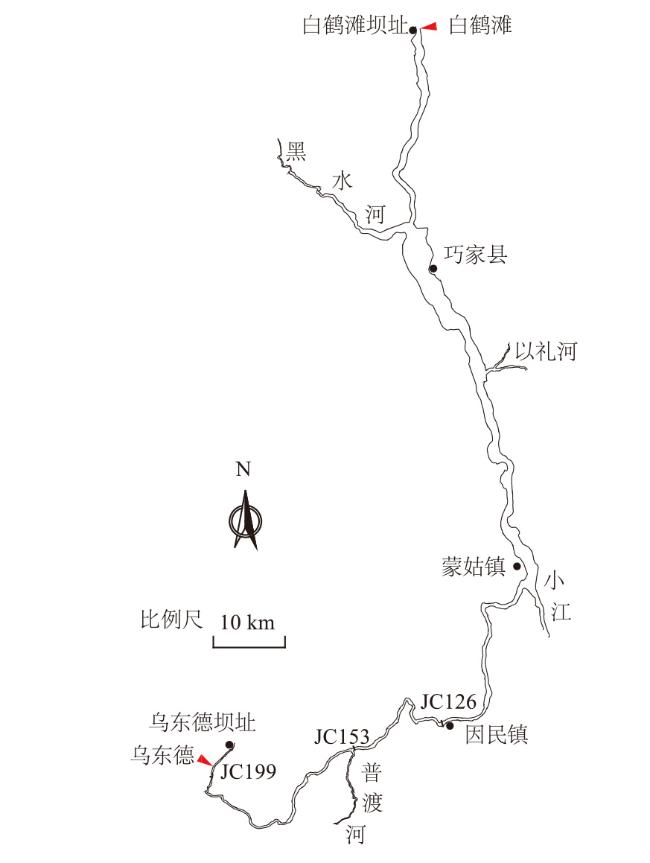
目前,对于三峡水库淤积特征的研究较多,主要采用实测资料和数学模型进行分析。本文研究白鹤滩水电站库区的淤积特征,白鹤滩水电站是金沙江下游梯级开发的第二级,库区全长180 km。乌东德水电站和白鹤滩水电站分别在2020年1月和2021年8月开始蓄水运行。2个电站的开发任务均以发电为主,兼顾防洪、航运和促进地方经济发展,其调度运行方式以供电为主,服从防汛调度。白鹤滩水库设计洪水位827.83 m,正常蓄水位825 m,防洪限制水位785 m,死水位765 m。随着枢纽运行,白鹤滩库区的水沙特性和河道演变出现新的变化。为此,本文依据实测水沙和固定断面资料,对白鹤滩库区水沙变化及冲淤特性进行深入分析,以期为白鹤滩水库安全运行及水域通航开发及河道整治提供科学依据。

1 研究区域与方法

白鹤滩库区位于金沙江下游峡谷内、两坝之间,两岸为高山,岸壁陡峭、支沟密布、江面宽窄相间,有4条主要支流,左岸有黑水河,右岸有普渡河、小江、以礼河,如图1所示。河段控制水文站为乌东德水文站和白鹤滩水文站,分别位于乌东德水电站下游4 km,白鹤滩水电站下游4.5 km。乌东德和白鹤滩水文站水文资料统计年限2015—2023年,地形资料为2016—2023年所测固定断面资料以及2023年11月份乌东德坝下游水流观测资料。
图1 研究区域示意图

Fig.1 Schematic diagram of the reservoir area from Baihetan to Wudongde

本次冲淤分析计算采用断面法[14]计算冲淤量。计算水位采用825 m水位,采用截锥公式计算相邻两断面间的河道槽蓄量。

2 水沙特性分析

2.1 径流量和输沙量年际变化趋势

乌东德和白鹤滩水文站年径流量与输沙量如图2所示。乌东德站2015—2019年间,平均年径流量为1 172亿m3,而2020—2023年间,平均年径流量下降为1 149亿m3,年径流量逐年波动,总体呈微幅减少趋势。白鹤滩站2015—2020年间,平均年径流量为1 292亿m3,而2021—2023年间,平均年径流量剧减为1 063亿m3,相比蓄水前降幅达17.8%。这主要是由于该时段内降雨量减少,且水电站处于未完全蓄满状态,共同导致径流量的明显下降。
图2 2个水文站径流量和输沙量年际变化过程

Fig.2 Interannual variations in runoff and sediment transport at two hydrological stations

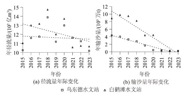
在输沙量方面,两站均呈现显著的下降趋势。乌东德站2015—2019年间,平均年输沙量为3 178万t,而2020—2023年间,平均年输沙量剧减至237万t,降幅高达93%;白鹤滩站输沙量变化更为剧烈,2015—2020年间,平均年输沙量为7 485万t,而2021—2023年间,平均年输沙量锐减至304万t,减少幅度达96%。这一趋势的加剧,主要是由于上游水库系统[15]对泥沙的有效拦截作用,即 “叠加拦沙效应”,显著降低了下游站点的年输沙量。

2.2 水沙年内分配变化

乌东德和白鹤滩两站的平均径流量随枢纽运行未发生显著变化,但年内径流过程却发生了明显的重新分配现象,如图3所示。这一现象主要是由于枢纽的调蓄作用,乌东德站和白鹤滩站月均径流量过程均出现典型“削峰填谷”趋势,其中白鹤滩的月径流重新分配效应更为显著。相较于蓄水前,乌东德站月均径流量的最大变化率在12月份(增加22%)和7月份(减少16%);白鹤滩站变化更为剧烈,分别在12月份(增加48%)和7月份(减少38%)。
图3 月均径流量和月均输沙量的时空分布特征

Fig.3 Spatiotemporal distribution characteristics of monthly average runoff and sediment transport

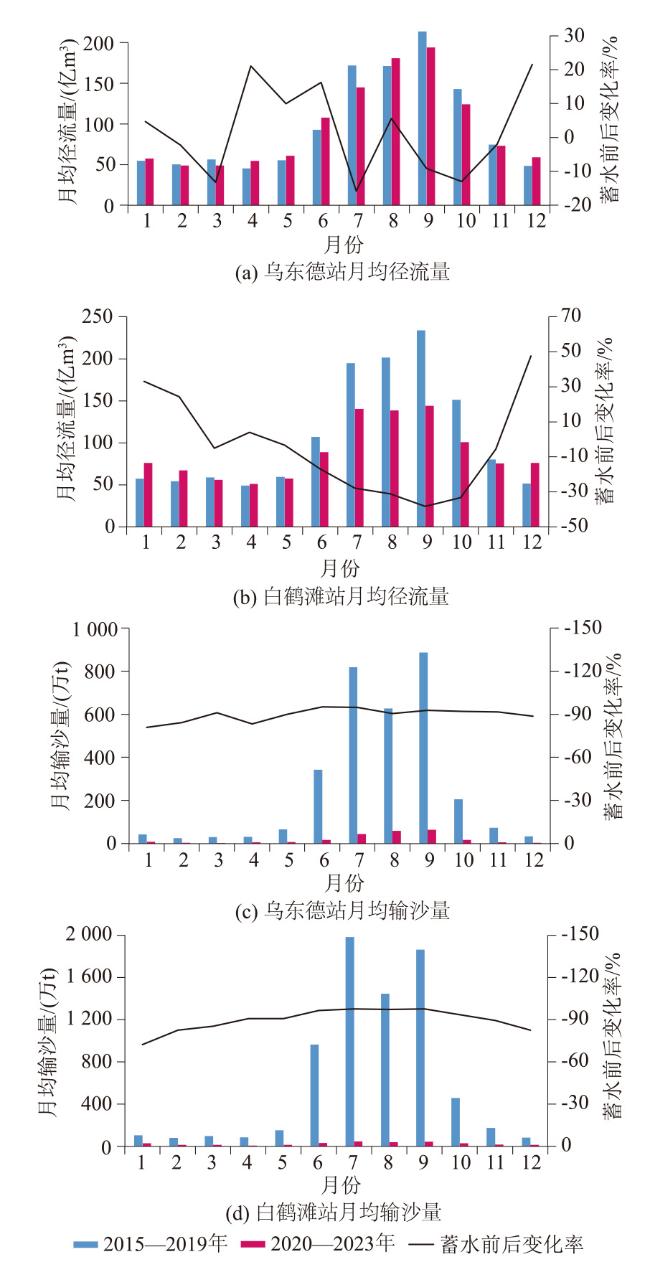
枢纽运行还影响了两站的月均输沙量,均呈现明显的下降趋势。对比蓄水前,乌东德站月均输沙量的最大降幅在6月份和7月份,均达到95%,而白鹤滩站在9月份出现最大降幅,为97%。月均输沙量的变化进一步揭示了两坝间河段输沙的季节性特征,主要集中在6—10月份期间,占全年输沙量的63%以上。值得注意的是,9月份月均输沙量自上游到下游逐渐递减,这一现象表明沿程可能发生淤积。

3 河床冲淤演变特性

3.1 河段冲淤量及冲淤时空分布

图4为乌东德和白鹤滩电站建成后河段各时段的冲淤量沿程变化。白鹤滩库区冲淤量时空变化特征如下。
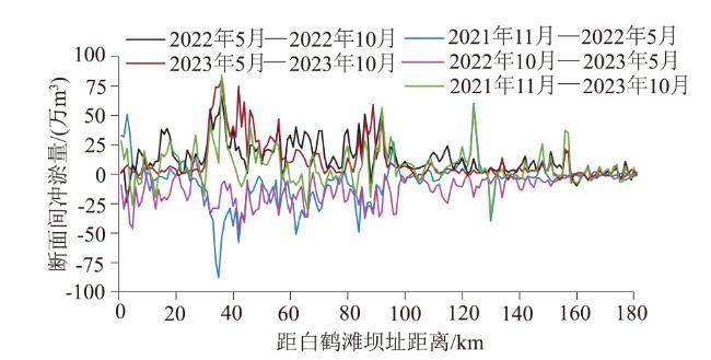
图4 冲淤量沿程变化

Fig.4 Longitudinal variation in erosion and deposition volumes

图4分析可知,在枯水期(每年10月至次年5月),白鹤滩库区呈现冲刷态势,2021年11月—2022年5月河段冲刷量为1 249万m3,2022年10月—2023年5月河段冲刷量增至2105万m3,增幅69%。在丰水期(5—10月份),该河段则整体转为淤积状态,2022年和2023年的丰水期,淤积量分别为2 546万m3和2 072万m3。2021年11月—2023年10月间,尽管存在季节性的冲刷与淤积交替,但河段整体呈淤积趋势,总淤积量达1 263万m3
从空间分布来看,白鹤滩库尾河段冲淤变化较为平缓,持续处于冲刷状态;冲淤量变化最为显著的区域则集中于白鹤滩坝址上游25~75 km的河段内。
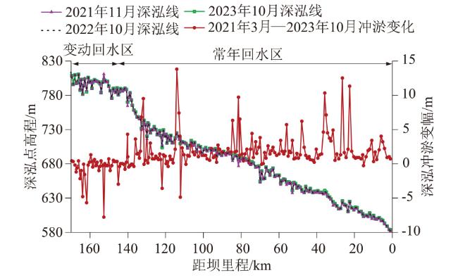
为深入揭示河段冲淤演变规律,本研究对典型年份的深泓线进行套绘分析,如图5所示。整体上,河段呈现以淤积为主的趋势,其中最大淤积高度达9 m,出现在距离白鹤滩枢纽约81 km的位置。而在库尾区域,深泓线则表现出明显的冲刷,最大冲刷深度8.85 m,该点距白鹤滩枢纽约152 km。
图5 典型年份深泓线

Fig.5 Overlay of thalweg lines in typical years

3.2 典型横断面形态变化

白鹤滩库区展现出3种典型的断面形态变化模式:库尾河段冲刷断面JC199、常年回水区的显著淤积断面JC126以及过渡段的相对稳定断面JC153。
JC199断面位于白鹤滩坝址上游163.8 km,为偏“U”型断面,如图6(a)所示。蓄水前(2016年11月—2021年3月),该断面主河槽显著下切,最大下切深度达10.5 m。蓄水后(2021年3月—2023年10月),冲刷作用持续,幅度有所减缓,最大下切达5.2 m,主要集中于深泓点附近。该断面位于库尾河段,河床下切幅度大极有可能是受人类活动影响。
图6 典型横断面变化

Fig.6 Variations in typical cross-sections

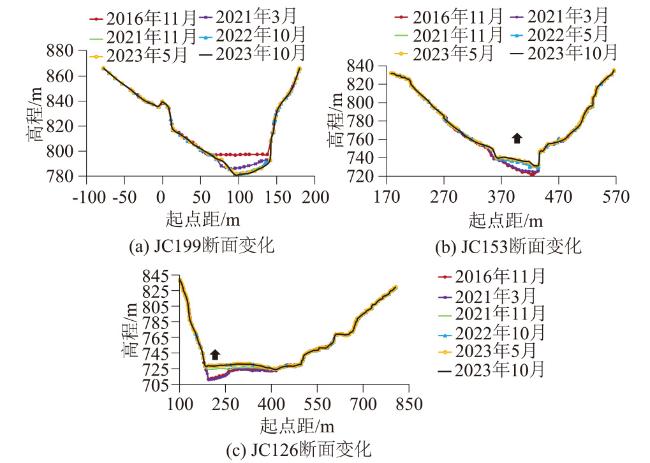
JC153断面位于普渡河口下游、白鹤滩坝址上游132.7 km,偏“V”型,如图6(b)所示。蓄水前(2016年11月—2021年3月),断面形态稳定,冲淤变幅较小。蓄水后(2021年3月—2023年10月),断面主河槽发生明显淤积,河床最大淤积厚度10.3 m,深泓点淤高6.8 m,其中2022年10月—2023年10月,断面冲淤变化较小,左岸近岸河床略有淤积。
JC126断面位于白鹤滩坝址上游114.0 km,偏“U”型,如图6(c)所示。蓄水前(2016年11月—2021年3月),该断面形态保持稳定,深泓紧贴左岸,冲淤变化幅度较小。蓄水后(2021年3月—2023年10月),断面主河槽发生“平铺式“淤积,河床最大淤积厚度达18.4 m,淤积最为严重的区域位于左岸附近,导致705~730 m区间的主河槽几乎被淤平,成为库区干流中深泓淤积最为显著的区域。此外,深泓点由左岸侧向右侧移动了约235 m,至断面中部。

4 冲淤特征影响因素分析

4.1 水流条件影响

2023年11月乌东德坝下游的水流观测资料如图7所示。乌东德坝下游的大比降、大流速区域主要集中在坝下20 km范围内,超出这一范围后,水位趋于稳定,主流速度显著降低。结合图4图5来看,乌东德坝下游20 km范围内,主要呈现冲刷状态,淤积相对较少。这是由于势能迅速转化为动能,导致该区域动能较大,挟沙能力增强,从而引发冲刷。而距离坝下游20 km以外的区域,水位变化趋于平稳,流速减缓,挟沙能力减小,发生淤积现象。
图7 乌东德坝下游水位、流速变化

Fig.7 Variations in water level and flow velocity downstream of Wudongde Dam

4.2 支流入汇影响

2021—2023年乌东德站年均输沙量为178万t,白鹤滩站年均输沙量为304万t,白鹤滩站输沙量大于乌东德站。2021年11月—2023年10月,白鹤滩库区河段总淤积量达到1 263万 m3。这一现象表明,白鹤滩库区的泥沙淤积并非干流输沙造成,而是由于区间支流的汇入。表1详细列出了白鹤滩支流的水沙变化特征,其中普渡河、小江、黑水河等支流对泥沙淤积的贡献显著。在2011—2022年,普渡河尼格站年均输沙量36.4万 t,小江年均输沙量122万 t,黑水河的控制站年均输沙量415万 t,区间支流入汇泥沙量较多,尤其是黑水河的来沙量最大。黑水河入汇口位于白鹤滩坝址上游约29 km处,从图4图5都可以看出该位置泥沙淤积显著。
表1 白鹤滩库区支流水沙变化特征

Table 1 Characteristics of water-sediment variations in tributaries of Baihetan Reservoir Area

年份 年径流量/(亿m3) 年输沙量/(万t)
尼格站
(普
渡河)
小江站
(小江)
宁南站
(黑水
河)
尼格站
(普渡
河)
小江站
(小江)
宁南站
(黑水
河)
2011—
2022
23.0 8.25 21.4 36.4 122 415
2023 16.2 6.19 13.0 246

注:小江站仅收集到2020—2023年的观测资料;2021年起宁南站受水库回水影响停止观测,表中为2011—2020年的平均值。

5 结论

(1)乌东德与白鹤滩水利枢纽的相继建成运行使两坝间河段的水沙关系发生了显著变化。年径流量略有减少,年内径流量呈现典型“削峰填谷”现象。同时,年输沙量均呈现显著下降,其中乌东德站年输沙量相比蓄水前减少93%,白鹤滩站减少96%。这主要是由于上游水库的叠加拦沙效应,进一步加剧了年输沙量的降低。
(2)白鹤滩库区河段河床冲淤变化深受水情条件及枢纽调度影响。在枯水期,由于来流含沙量小,河床往往经历冲刷过程;而在汛期,随着来流含沙量的增加,流域产沙的增加,河床则倾向于发生淤积。从长期趋势来看,河床的冲淤变化更多地受到枢纽控制的影响。尽管短期内存在冲淤交替,但长时间尺度上,该河段总体上呈累积淤积的态势。在空间分布上,库尾区域由于水流条件特殊,往往成为冲刷区域;而坝前区域,则由于水流速度减缓、泥沙沉积增加,成为淤积区域。另外,支流河口区域淤积明显,表明支流的来沙量也对白鹤滩库区的泥沙淤积有重要的贡献作用。
[1]
周银军, 王军, 徐育平, 等. 长江黄陵庙至南津关河段河势分析[J]. 水利水运工程学报, 2015(1): 38-46.

(ZHOU Yin-jun, WANG Jun, XU Yu-ping, et al. River Channel Process of Huanglingmiao-Nanjinguan River Reach[J]. Hydro-Science and Engineering, 2015(1): 38-46. ) (in Chinese)

[2]
史常乐, 牛兰花, 赵国龙, 等. 三峡大坝-葛洲坝河段水沙变化及冲淤特性[J]. 水科学进展, 2020, 31(6):875-884.

(SHI Chang-le, NIU Lan-hua, ZHAO Guo-long, et al. Variation in Water and Sediment Conditions and Erosion and Deposition Characteristics in the Reach between Three Gorges Dam and Gezhou Dam[J]. Advances in Water Science, 2020, 31(6): 875-884. (in Chinese))

[3]
杨成刚, 许全喜, 董炳江, 等. 三峡水库泥沙实时预报关键技术研究及应用: 以2020年汛期为例[J]. 人民长江, 2020, 51(12): 82-87.

(YANG Cheng-gang, XU Quan-xi, DONG Bing-jiang, et al. Research and Application of Key Technology on Real-time Sediment Forecast of Three Gorges Reservoir: Case of Flood Season in 2020[J]. Yangtze River, 2020, 51(12): 82-87.(in Chinese))

[4]
姜利玲, 董炳江, 汤成友, 等. 长江上游三峡水库入库泥沙沙峰传播时间研究[J]. 人民长江, 2021, 52(7): 9-16.

(JIANG Li-ling, DONG Bing-jiang, TANG Cheng-you, et al. Study on Sand Peak Propagation Time of Input Sediment of Three Gorges Reservoir in Upper Changjiang River[J]. Yangtze River, 2021, 52(7): 9-16.(in Chinese))

[5]
王玉璇, 金中武, 陈鹏. 三峡水库汛期排沙效率研究[J]. 人民长江, 2022, 53(5): 14-19.

(WANG Yu-xuan, JIN Zhong-wu, CHEN Peng. Study on Sediment Transport Efficiency of Three Gorges Reservoir during Flood Season[J]. Yangtze River, 2022, 53(5): 14-19.(in Chinese))

[6]
侯素珍, 胡恬, 杨飞, 等. 三门峡水库汛期排沙效果研究[J]. 水利学报, 2021, 52(4): 393-400.

(HOU Su-zhen, HU Tian, YANG Fei, et al. Research on the Causes of Sediment Discharge of Sanmenxia Reservoir during Flood Season[J]. Journal of Hydraulic Engineering, 2021, 52(4): 393-400.(in Chinese))

[7]
黄仁勇, 王敏, 张细兵, 等. 溪洛渡、向家坝、三峡梯级水库汛期联合排沙调度方式初步研究[J]. 长江科学院院报, 2018, 35(8): 6-10, 26.

DOI

(HUANG Ren-yong, WANG Min, ZHANG Xi-bing, et al. Preliminary Study on Joint Desilting Dispatching Mode of Xiluodu, Xiangjiaba and Three Gorges Cascade Reservoirs in Flood Season[J]. Journal of Yangtze River Scientific Research Institute, 2018, 35(8): 6-10, 26.(in Chinese))

DOI

[8]
许全喜, 董炳江, 袁晶, 等. 三峡工程运用后长江中下游河道冲刷特征及其影响[J]. 湖泊科学, 2023, 35(2):650-661.

(XU Quan-xi, DONG Bing-jiang, YUAN Jing, et al. Scouring Effect of the Middle and Lower Reaches of the Yangtze River and Its Impact after the Impoundment of the Three Gorges Project[J]. Journal of Lake Sciences, 2023, 35(2): 650-661. (in Chinese))

[9]
袁晶, 许全喜, 董炳江, 等. 近20年来三峡水库泥沙淤积及其对库区的影响[J]. 湖泊科学, 2023, 35(2):632-641.

(YUAN Jing, XU Quan-xi, DONG Bing-jiang, et al. Sediment Deposition of Three Gorges Reservior and Its Impact on the Reservoir Area in Recent 20 years[J]. Journal of Lake Sciences, 2023, 35(2): 632-641. (in Chinese))

[10]
朱玲玲, 董先勇, 陈泽方. 金沙江下游梯级水库淤积及其对三峡水库影响研究[J]. 长江科学院院报, 2017, 34(3):1-7.

DOI

(ZHU Ling-ling, DONG Xian-yong, CHEN Ze-fang. Sediment Deposition of Cascade Reservoirs in the Lower Jinsha River and Its Impact on Three Gorges Reservoir[J]. Journal of Changjiang River Scientific Research Institute, 2017, 34(3): 1-7. (in Chinese))

[11]
朱玲玲, 陈迪, 杨成刚, 等. 金沙江下游梯级水库泥沙淤积和坝下河道冲刷规律[J]. 湖泊科学, 2023, 53(5): 1097-1110.

(ZHU Ling-ling, CHEN Di, YANG Cheng-gang, et al. Sediment Deposition of Cascade Reservoirs in the Lower Jinsha River and Scouring of River Channel under Dam[J]. Journal of Lake Sciences, 2023, 53(5): 1097-1110. (in Chinese))

[12]
杨春瑞, 邓金运, 陈立. 复杂边界作用下三峡水库泥沙淤积特征与趋势[J]. 水科学进展, 2023, 34(3): 442-453.

(YANG Chun-rui, DENG Jin-yun, CHEN Li. Sediment Deposition Trend in the Three Gorges Reservoir under the Action of Complex Boundary Conditions[J]. Advances in Water Science, 2023, 34(3): 442-453.(in Chinese))

[13]
曹双, 程龙, 李洁, 等. 2020年流域性大洪水下长江下游干流河道演变分析[J]. 水利水运工程学报, 2023(4):1-11.

(CAO Shuang, CHENG Long, LI Jie, et al. Analysis on the Evolution of the Main Stream of the Lower Reaches of the Yangtze River under the Basin Flood in 2020[J]. China Industrial Economics, 2023(4): 1-11.

[14]
张成潇, 米博宇, 吕超楠, 等. 高洪水期运行水位对三峡水库泥沙淤积的影响[J]. 长江科学院院报, 2024, 41(6):10-17,35.

DOI

(ZHANG Cheng-xiao, MI Bo-yu, Chao-nan, et al. Influence of Operating Water Level on Sediment Deposition in the Three Gorges Reservior during High Flood Levels[J]. Journal of Changjiang River Scientific Research Institute, 2024, 41(6): 10-17,35.(in Chinese))

[15]
张国帅, 邓安军, 张帮稳, 等. 水库运用对金沙江下游水沙变化的影响[J]. 湖泊科学, 2024, 36(6): 1911-1921.

(ZHANG Guo-shuai, DENG An-jun, ZHANG Bang-wen, et al. The Impact of Reservoir Operation on Runoff and Sediment Load Change in the Lower Jinsha River[J]. Journal of Lake Sciences, 2023, 35(3):1097-1110. (in Chinese))

文章导航

/